Grävenwiesbach geodata
Grävenwiesbach (Hesse) is a seat of a fourth-order administrative division; located in Germany in Europe/Berlin (GMT+2) time zone. With population of 5,245 people, there are 2719 cities with bigger population in this country. Compared to other cities in Germany, 54.9% of cities are located further ↑North; 71.5% of cities are located further →East and 61.1% of cities have lower elevation than Grävenwiesbach. Note1
Administrative division(s):
- Level 1: Hesse
- Level 2: Regierungsbezirk Darmstadt
- Level 3: Hochtaunuskreis
- Level 4: Grävenwiesbach


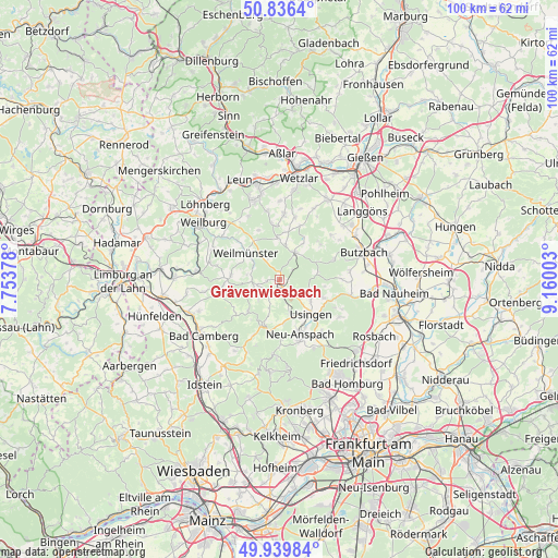
Grävenwiesbach GPS coordinates[2]
50° 23' 24.864" North, 8° 27' 24.84" East
| Map corner | latitude | longitude |
|---|---|---|
| Upper-left | 50.8364°, | 7.75378° |
| Center: | 50.39024°, | 8.4569° |
| Lower-right: | 49.93984°, | 9.16003° |
| Map W x H: | 99.7×99.7 km | = 62×62mi |
| max Lat: | 55.01917° ⇑54.9% North |
| Grävenwiesbach: | 50.39024° |
| min Lat: | ⇓45.1% South 47.40724° |
| min Long | Grävenwiesbach | max Long |
| 5.92978° | 8.4569° | 14.98853° |
| W 28.5%⇐ | ⇒71.5% E |
Elevation
Elevation of Grävenwiesbach is 296 m = 971 ft, and this is 46.9 m = 154 ft above average elevation for this country.
| Max E: |
1256 m = 4121 ft | 38.9% |
| Grävenwiesbach | 296 m 971 ft | |
| Avg. | 249.1 m = 817 ft | |
Min E: |
-5 m = -16 ft | 61.1% |
See also: Germany elevation on elevation.city.
Geographical zone
Grävenwiesbach is located in North temperate zone (between Tropic of Cancer and the Arctic Circle). Distance of this North polar circle is 1798.3 km =1117.4 mi to North.| Distance of | km | miles | from Grävenwiesbach |
|---|---|---|---|
| North Pole | 4404.2 | 2736.6 | to North |
| Arctic Circle | 1798.3 | 1117.4 | to North |
| Tropic Cancer | 2997 | 1862.2 | to South |
| Equator | 5602.9 | 3481.5 | to South |


Nearby cities:
15 places around Grävenwiesbach: (largest is in red/bold)
• Albshausen
17.2 km =10.7 mi,  355°
355°
• Bad Camberg
16.9 km =10.5 mi,  232°
232°
• Braunfels
14.7 km =9.1 mi,  340°
340°
• Butzbach
15.9 km =9.9 mi,  72°
72°
• Laufdorf
14 km =8.7 mi,  0°
0°
• Neu-Anspach
8.7 km =5.4 mi,  159°
159°
• Ober-Mörlen
16.7 km =10.4 mi,  96°
96°
• Schmitten
13.7 km =8.5 mi,  182°
182°
• Schwalbach
11.9 km =7.4 mi, 4°
• Schöffengrund
11.5 km =7.1 mi,  5°
5°
• Solms
16.6 km =10.3 mi,  347°
347°
• Usingen
8.3 km =5.2 mi,  136°
136°
• Wehrheim
12.7 km =7.9 mi, 142°
• Weilmünster
7.3 km =4.5 mi,  308°
308°
• Weinbach
12.9 km =8 mi,  294°
294°
Sources, notices
• [Note1] Compared only with cities in Germany existing in our database
• [Src1] Map data: © OpenStreetMap contributors (CC-BY-SA)
• [Src2] Other city data from geonames.org with taken over terms of usage.
• [Src3] Geographical zone / Annual Mean Temperature by Robert A. Rohde @ Wikipedia
