Albshausen geodata
Albshausen (Hesse) is a section of populated place; located in Germany in Europe/Berlin (GMT+2) time zone. With population of 1,992 people, there are 5084 cities with bigger population in this country. Compared to other cities in Germany, 51.8% of cities are located further ↑North; 71.6% of cities are located further →East and 59.7% of cities have higher elevation than Albshausen. Note1
Administrative division(s):
- Level 1: Hesse
- Level 2: Regierungsbezirk Gießen
- Level 3: Lahn-Dill-Kreis
- Level 4: Solms


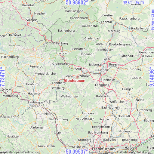
Albshausen GPS coordinates[2]
50° 32' 39.516" North, 8° 26' 16.224" East
| Map corner | latitude | longitude |
|---|---|---|
| Upper-left | 50.98902°, | 7.73471° |
| Center: | 50.54431°, | 8.43784° |
| Lower-right: | 50.09537°, | 9.14096° |
| Map W x H: | 99.4×99.4 km | = 61.8×61.8mi |
| max Lat: | 55.01917° ⇑51.8% North |
| Albshausen: | 50.54431° |
| min Lat: | ⇓48.2% South 47.40724° |
| min Long | Albshausen | max Long |
| 5.92978° | 8.43784° | 14.98853° |
| W 28.4%⇐ | ⇒71.6% E |
Elevation
Elevation of Albshausen is 155 m = 509 ft, and this is 94.1 m = 309 ft below average elevation for this country.
| Max E: |
1256 m = 4121 ft | 59.7% |
| Avg. | 249.1 m = 817 ft | |
| Albshausen | 155 m = 509 ft | |
Min E: |
-5 m = -16 ft | 40.3% |
See also: Germany elevation on elevation.city.
Geographical zone
Albshausen is located in North temperate zone (between Tropic of Cancer and the Arctic Circle). Distance of this North polar circle is 1781.2 km =1106.8 mi to North.| Distance of | km | miles | from Albshausen |
|---|---|---|---|
| North Pole | 4387.1 | 2726 | to North |
| Arctic Circle | 1781.2 | 1106.8 | to North |
| Tropic Cancer | 3014.1 | 1872.9 | to South |
| Equator | 5620 | 3492.1 | to South |


Nearby cities:
15 places around Albshausen: (largest is in red/bold)
• Aßlar
5.5 km =3.4 mi,  18°
18°
• Braunfels
4.7 km =2.9 mi,  226°
226°
• Burgsolms
2.4 km =1.5 mi,  263°
263°
• Ehringshausen
7.3 km =4.5 mi,  328°
328°
• Greifenstein
12.6 km =7.8 mi,  309°
309°
• Laufdorf
3.5 km =2.2 mi,  153°
153°
• Leun
5.7 km =3.5 mi,  277°
277°
• Löhnberg
12.2 km =7.6 mi,  253°
253°
• Niederbiel
3 km =1.9 mi,  293°
293°
• Oberbiel
1.2 km =0.7 mi,  324°
324°
• Schwalbach
5.7 km =3.5 mi,  157°
157°
• Schöffengrund
6.1 km =3.8 mi, 156°
• Selters
10.9 km =6.8 mi, 253°
• Solms
2.4 km =1.5 mi, 247°
• Wetzlar
5.1 km =3.2 mi,  68°
68°
Sources, notices
• [Note1] Compared only with cities in Germany existing in our database
• [Src1] Map data: © OpenStreetMap contributors (CC-BY-SA)
• [Src2] Other city data from geonames.org with taken over terms of usage.
• [Src3] Geographical zone / Annual Mean Temperature by Robert A. Rohde @ Wikipedia
