Paulsstadt geodata
Paulsstadt (Mecklenburg-Vorpommern) is a section of populated place; located in Germany in Europe/Berlin (GMT+2) time zone. With population of 8,299 people, there are 1903 cities with bigger population in this country. Compared to other cities in Germany, 87.5% of cities are located further ↓South; 72.7% of cities are located further ←West and 76.1% of cities have higher elevation than Paulsstadt. Note1
Administrative division(s):
- Level 1: Mecklenburg-Vorpommern
- Level 3: Kreisfreie Stadt Schwerin
- Level 4: Schwerin, Landeshauptstadt


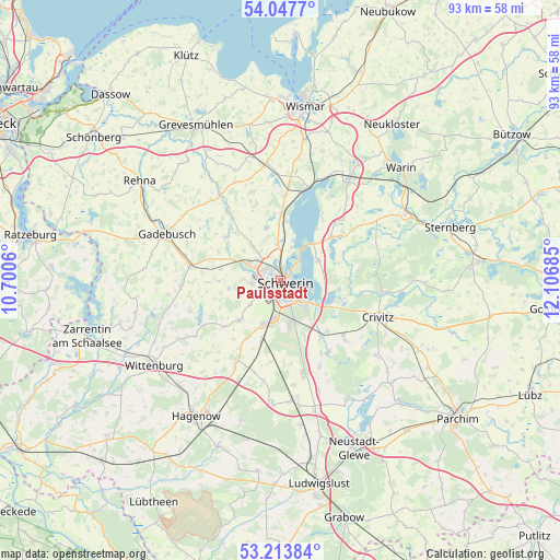
Paulsstadt GPS coordinates[2]
53° 37' 58.188" North, 11° 24' 13.392" East
| Map corner | latitude | longitude |
|---|---|---|
| Upper-left | 54.0477°, | 10.7006° |
| Center: | 53.63283°, | 11.40372° |
| Lower-right: | 53.21384°, | 12.10685° |
| Map W x H: | 92.7×92.7 km | = 57.6×57.6mi |
| max Lat: | 55.01917° ⇑12.5% North |
| Paulsstadt: | 53.63283° |
| min Lat: | ⇓87.5% South 47.40724° |
| min Long | Paulsstadt | max Long |
| 5.92978° | 11.40372° | 14.98853° |
| W 72.7%⇐ | ⇒27.3% E |
Elevation
Elevation of Paulsstadt is 59 m = 194 ft, and this is 190.1 m = 624 ft below average elevation for this country.
| Max E: |
1256 m = 4121 ft | 76.1% |
| Avg. | 249.1 m = 817 ft | |
| Paulsstadt | 59 m = 194 ft | |
Min E: |
-5 m = -16 ft | 23.9% |
See also: Germany elevation on elevation.city.
Geographical zone
Paulsstadt is located in North temperate zone (between Tropic of Cancer and the Arctic Circle). Distance of this North polar circle is 1437.8 km =893.4 mi to North.| Distance of | km | miles | from Paulsstadt |
|---|---|---|---|
| North Pole | 4043.7 | 2512.6 | to North |
| Arctic Circle | 1437.8 | 893.4 | to North |
| Tropic Cancer | 3357.5 | 2086.3 | to South |
| Equator | 5963.4 | 3705.5 | to South |


Nearby cities:
15 places around Paulsstadt: (largest is in red/bold)
• Altstadt
1 km =0.6 mi,  123°
123°
• Feldstadt
1.1 km =0.7 mi,  169°
169°
• Klein Rogahn
4.9 km =3 mi,  231°
231°
• Lankow
3 km =1.9 mi,  309°
309°
• Leezen
7.1 km =4.4 mi,  62°
62°
• Lewenberg
1.5 km =0.9 mi,  10°
10°
• Neumühle
2.2 km =1.4 mi,  266°
266°
• Pingelshagen
7.2 km =4.5 mi,  321°
321°
• Raben Steinfeld
7.5 km =4.7 mi, 117°
• Schelfstadt
0.9 km =0.6 mi,  82°
82°
• Schwerin
0.7 km =0.4 mi, 121°
• Seehof
6.9 km =4.3 mi,  15°
15°
• Werdervorstadt
1.7 km =1.1 mi,  66°
66°
• Weststadt
0.6 km =0.4 mi,  291°
291°
• Wittenförden
4.9 km =3 mi, 265°
Sources, notices
• [Note1] Compared only with cities in Germany existing in our database
• [Src1] Map data: © OpenStreetMap contributors (CC-BY-SA)
• [Src2] Other city data from geonames.org with taken over terms of usage.
• [Src3] Geographical zone / Annual Mean Temperature by Robert A. Rohde @ Wikipedia
