Luisenthal geodata
Luisenthal (Saarland) is a seat of a fourth-order administrative division; located in Germany in Europe/Berlin (GMT+2) time zone. With population of 1,636 people, there are 5627 cities with bigger population in this country. Compared to other cities in Germany, 79.6% of cities are located further ↑North; 94.5% of cities are located further →East and 54.5% of cities have higher elevation than Luisenthal. Note1
Administrative division(s):
- Level 1: Saarland
- Level 3: Regionalverband Saarbrücken
- Level 4: Völklingen


Luisenthal GPS coordinates[2]
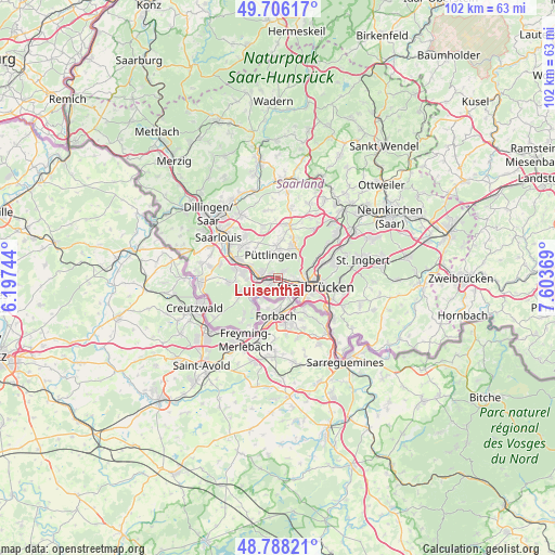
49° 14' 57.552" North, 6° 54' 2.052" East
| Map corner | latitude | longitude |
|---|---|---|
| Upper-left | 49.70617°, | 6.19744° |
| Center: | 49.24932°, | 6.90057° |
| Lower-right: | 48.78821°, | 7.60369° |
| Map W x H: | 102.1×102.1 km | = 63.4×63.4mi |
| max Lat: | 55.01917° ⇑79.6% North |
| Luisenthal: | 49.24932° |
| min Lat: | ⇓20.4% South 47.40724° |
| min Long | Luisenthal | max Long |
| 5.92978° | 6.90057° | 14.98853° |
| W 5.5%⇐ | ⇒94.5% E |
Elevation
Elevation of Luisenthal is 193 m = 633 ft, and this is 56.1 m = 184 ft below average elevation for this country.
| Max E: |
1256 m = 4121 ft | 54.5% |
| Avg. | 249.1 m = 817 ft | |
| Luisenthal | 193 m = 633 ft | |
Min E: |
-5 m = -16 ft | 45.5% |
See also: Germany elevation on elevation.city.
Geographical zone
Luisenthal is located in North temperate zone (between Tropic of Cancer and the Arctic Circle). Distance of this North polar circle is 1925.2 km =1196.3 mi to North.| Distance of | km | miles | from Luisenthal |
|---|---|---|---|
| North Pole | 4531.1 | 2815.5 | to North |
| Arctic Circle | 1925.2 | 1196.3 | to North |
| Tropic Cancer | 2870.1 | 1783.4 | to South |
| Equator | 5476 | 3402.6 | to South |


Nearby cities:
15 places around Luisenthal: (largest is in red/bold)
• Bous
7.8 km =4.8 mi,  293°
293°
• Fenne
1.2 km =0.7 mi,  257°
257°
• Fürstenhausen
2.5 km =1.6 mi,  247°
247°
• Großrosseln
6.7 km =4.2 mi,  219°
219°
• Heidstock
1.6 km =1 mi,  297°
297°
• Hostenbach
6.5 km =4 mi,  284°
284°
• Ludweiler-Warndt
7.2 km =4.5 mi,  243°
243°
• Püttlingen
4.1 km =2.5 mi,  346°
346°
• Riegelsberg
6.1 km =3.8 mi,  22°
22°
• Röchling-Höhe
5.4 km =3.4 mi, 296°
• Saarbrücken
8.1 km =5 mi,  103°
103°
• Schaffhausen
6.6 km =4.1 mi, 276°
• Schwalbach
8.3 km =5.2 mi,  312°
312°
• Völklingen
3 km =1.9 mi,  274°
274°
• Wadgassen
8.7 km =5.4 mi, 282°
Sources, notices
• [Note1] Compared only with cities in Germany existing in our database
• [Src1] Map data: © OpenStreetMap contributors (CC-BY-SA)
• [Src2] Other city data from geonames.org with taken over terms of usage.
• [Src3] Geographical zone / Annual Mean Temperature by Robert A. Rohde @ Wikipedia
