Sachsenheim geodata
Sachsenheim (Baden-Württemberg) is a seat of a fourth-order administrative division; located in Germany in Europe/Berlin (GMT+2) time zone. With population of 18,594 people, there are 844 cities with bigger population in this country. Compared to other cities in Germany, 83.4% of cities are located further ↑North; 64.6% of cities are located further →East and 51.9% of cities have lower elevation than Sachsenheim. Note1
Administrative division(s):
- Level 1: Baden-Württemberg
- Level 2: Regierungsbezirk Stuttgart
- Level 3: Landkreis Ludwigsburg
- Level 4: Sachsenheim


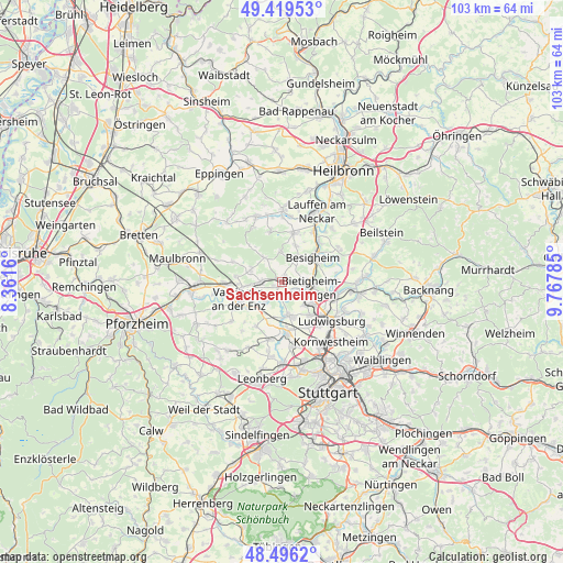
Sachsenheim GPS coordinates[2]
48° 57' 36" North, 9° 3' 52.992" East
| Map corner | latitude | longitude |
|---|---|---|
| Upper-left | 49.41953°, | 8.3616° |
| Center: | 48.96°, | 9.06472° |
| Lower-right: | 48.4962°, | 9.76785° |
| Map W x H: | 102.7×102.7 km | = 63.8×63.8mi |
| max Lat: | 55.01917° ⇑83.4% North |
| Sachsenheim: | 48.96° |
| min Lat: | ⇓16.6% South 47.40724° |
| min Long | Sachsenheim | max Long |
| 5.92978° | 9.06472° | 14.98853° |
| W 35.4%⇐ | ⇒64.6% E |
Elevation
Elevation of Sachsenheim is 239 m = 784 ft, and this is 10.1 m = 33 ft below average elevation for this country.
| Max E: |
1256 m = 4121 ft | 48.1% |
| Avg. | 249.1 m = 817 ft | |
| Sachsenheim | 239 m = 784 ft | |
Min E: |
-5 m = -16 ft | 51.9% |
See also: Germany elevation on elevation.city.
Geographical zone
Sachsenheim is located in North temperate zone (between Tropic of Cancer and the Arctic Circle). Distance of this North polar circle is 1957.3 km =1216.2 mi to North.| Distance of | km | miles | from Sachsenheim |
|---|---|---|---|
| North Pole | 4563.2 | 2835.4 | to North |
| Arctic Circle | 1957.3 | 1216.2 | to North |
| Tropic Cancer | 2837.9 | 1763.4 | to South |
| Equator | 5443.8 | 3382.6 | to South |


Nearby cities:
15 places around Sachsenheim: (largest is in red/bold)
• Asperg
8 km =5 mi,  139°
139°
• Besigheim
7.1 km =4.4 mi,  53°
53°
• Bietigheim-Bissingen
4.2 km =2.6 mi,  114°
114°
• Bönnigheim
9.2 km =5.7 mi,  13°
13°
• Erligheim
7.3 km =4.5 mi,  18°
18°
• Freudental
5.5 km =3.4 mi,  355°
355°
• Löchgau
5.7 km =3.5 mi,  32°
32°
• Markgröningen
6.2 km =3.9 mi,  169°
169°
• Möglingen
9.3 km =5.8 mi,  150°
150°
• Oberriexingen
4.6 km =2.9 mi,  216°
216°
• Schwieberdingen
9.3 km =5.8 mi,  175°
175°
• Sersheim
3.6 km =2.2 mi,  281°
281°
• Tamm
5.8 km =3.6 mi, 140°
• Vaihingen an der Enz
8.1 km =5 mi,  250°
250°
• Walheim
8.7 km =5.4 mi, 46°
Sources, notices
• [Note1] Compared only with cities in Germany existing in our database
• [Src1] Map data: © OpenStreetMap contributors (CC-BY-SA)
• [Src2] Other city data from geonames.org with taken over terms of usage.
• [Src3] Geographical zone / Annual Mean Temperature by Robert A. Rohde @ Wikipedia
