Besigheim geodata
Besigheim (Baden-Württemberg) is a populated place; located in Germany in Europe/Berlin (GMT+2) time zone. With population of 11,883 people, there are 1381 cities with bigger population in this country. Compared to other cities in Germany, 83.1% of cities are located further ↑North; 63.3% of cities are located further →East and 54.2% of cities have higher elevation than Besigheim. Note1
Administrative division(s):
- Level 1: Baden-Württemberg
- Level 2: Regierungsbezirk Stuttgart
- Level 3: Landkreis Ludwigsburg
- Level 4: Besigheim


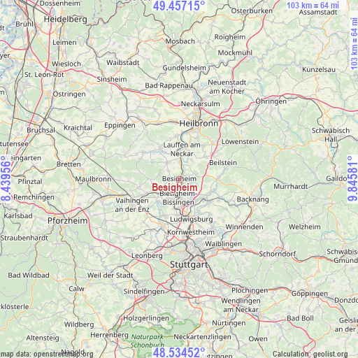
Besigheim GPS coordinates[2]
48° 59' 52.692" North, 9° 8' 33.648" East
| Map corner | latitude | longitude |
|---|---|---|
| Upper-left | 49.45715°, | 8.43956° |
| Center: | 48.99797°, | 9.14268° |
| Lower-right: | 48.53452°, | 9.84581° |
| Map W x H: | 102.6×102.6 km | = 63.8×63.8mi |
| max Lat: | 55.01917° ⇑83.1% North |
| Besigheim: | 48.99797° |
| min Lat: | ⇓16.9% South 47.40724° |
| min Long | Besigheim | max Long |
| 5.92978° | 9.14268° | 14.98853° |
| W 36.7%⇐ | ⇒63.3% E |
Elevation
Elevation of Besigheim is 195 m = 640 ft, and this is 54.1 m = 177 ft below average elevation for this country.
| Max E: |
1256 m = 4121 ft | 54.2% |
| Avg. | 249.1 m = 817 ft | |
| Besigheim | 195 m = 640 ft | |
Min E: |
-5 m = -16 ft | 45.8% |
See also: Germany elevation on elevation.city.
Geographical zone
Besigheim is located in North temperate zone (between Tropic of Cancer and the Arctic Circle). Distance of this North polar circle is 1953.1 km =1213.6 mi to North.| Distance of | km | miles | from Besigheim |
|---|---|---|---|
| North Pole | 4559 | 2832.8 | to North |
| Arctic Circle | 1953.1 | 1213.6 | to North |
| Tropic Cancer | 2842.1 | 1766 | to South |
| Equator | 5448.1 | 3385.3 | to South |


Nearby cities:
15 places around Besigheim: (largest is in red/bold)
• Bietigheim-Bissingen
6.3 km =3.9 mi,  197°
197°
• Bönnigheim
5.9 km =3.7 mi,  322°
322°
• Erligheim
4.3 km =2.7 mi,  309°
309°
• Freiberg am Neckar
8.5 km =5.3 mi,  149°
149°
• Freudental
6.2 km =3.9 mi,  282°
282°
• Gemmrigheim
3.5 km =2.2 mi,  15°
15°
• Hessigheim
3.2 km =2 mi,  97°
97°
• Kirchheim am Neckar
5.2 km =3.2 mi,  359°
359°
• Lauffen am Neckar
8.4 km =5.2 mi,  1°
1°
• Löchgau
2.7 km =1.7 mi, 283°
• Mundelsheim
4.8 km =3 mi,  86°
86°
• Neckarwestheim
6.4 km =4 mi,  32°
32°
• Pleidelsheim
6.2 km =3.9 mi,  134°
134°
• Sachsenheim
7.1 km =4.4 mi,  233°
233°
• Walheim
1.9 km =1.2 mi, 18°
Sources, notices
• [Note1] Compared only with cities in Germany existing in our database
• [Src1] Map data: © OpenStreetMap contributors (CC-BY-SA)
• [Src2] Other city data from geonames.org with taken over terms of usage.
• [Src3] Geographical zone / Annual Mean Temperature by Robert A. Rohde @ Wikipedia
