Walheim geodata
Walheim (Baden-Württemberg) is a seat of a fourth-order administrative division; located in Germany in Europe/Berlin (GMT+2) time zone. With population of 3,057 people, there are 3954 cities with bigger population in this country. Compared to other cities in Germany, 82.9% of cities are located further ↑North; 63.1% of cities are located further →East and 54.6% of cities have higher elevation than Walheim. Note1
Administrative division(s):
- Level 1: Baden-Württemberg
- Level 2: Regierungsbezirk Stuttgart
- Level 3: Landkreis Ludwigsburg
- Level 4: Walheim


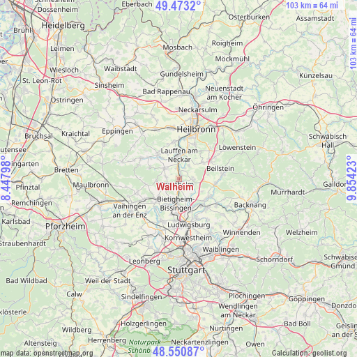
Walheim GPS coordinates[2]
49° 0' 51.012" North, 9° 9' 3.996" East
| Map corner | latitude | longitude |
|---|---|---|
| Upper-left | 49.4732°, | 8.44798° |
| Center: | 49.01417°, | 9.15111° |
| Lower-right: | 48.55087°, | 9.85423° |
| Map W x H: | 102.6×102.6 km | = 63.8×63.8mi |
| max Lat: | 55.01917° ⇑82.9% North |
| Walheim: | 49.01417° |
| min Lat: | ⇓17.1% South 47.40724° |
| min Long | Walheim | max Long |
| 5.92978° | 9.15111° | 14.98853° |
| W 36.9%⇐ | ⇒63.1% E |
Elevation
Elevation of Walheim is 192 m = 630 ft, and this is 57.1 m = 187 ft below average elevation for this country.
| Max E: |
1256 m = 4121 ft | 54.6% |
| Avg. | 249.1 m = 817 ft | |
| Walheim | 192 m = 630 ft | |
Min E: |
-5 m = -16 ft | 45.4% |
See also: Germany elevation on elevation.city.
Geographical zone
Walheim is located in North temperate zone (between Tropic of Cancer and the Arctic Circle). Distance of this North polar circle is 1951.3 km =1212.5 mi to North.| Distance of | km | miles | from Walheim |
|---|---|---|---|
| North Pole | 4557.2 | 2831.7 | to North |
| Arctic Circle | 1951.3 | 1212.5 | to North |
| Tropic Cancer | 2843.9 | 1767.1 | to South |
| Equator | 5449.9 | 3386.4 | to South |


Nearby cities:
15 places around Walheim: (largest is in red/bold)
• Besigheim
1.9 km =1.2 mi,  198°
198°
• Bietigheim-Bissingen
8.2 km =5.1 mi, 197°
• Bönnigheim
5.1 km =3.2 mi,  304°
304°
• Erligheim
4 km =2.5 mi,  283°
283°
• Freudental
6.7 km =4.2 mi,  265°
265°
• Gemmrigheim
1.6 km =1 mi,  11°
11°
• Hessigheim
3.4 km =2.1 mi,  131°
131°
• Ilsfeld
8.3 km =5.2 mi,  56°
56°
• Kirchheim am Neckar
3.5 km =2.2 mi,  349°
349°
• Lauffen am Neckar
6.6 km =4.1 mi,  356°
356°
• Löchgau
3.5 km =2.2 mi,  250°
250°
• Mundelsheim
4.4 km =2.7 mi,  109°
109°
• Neckarwestheim
4.6 km =2.9 mi,  37°
37°
• Pleidelsheim
7.2 km =4.5 mi,  148°
148°
• Talheim
8.3 km =5.2 mi,  21°
21°
Sources, notices
• [Note1] Compared only with cities in Germany existing in our database
• [Src1] Map data: © OpenStreetMap contributors (CC-BY-SA)
• [Src2] Other city data from geonames.org with taken over terms of usage.
• [Src3] Geographical zone / Annual Mean Temperature by Robert A. Rohde @ Wikipedia
