Ulfborg geodata
Ulfborg (Central Jutland) is a populated place; located in Denmark in Europe/Copenhagen (GMT+2) time zone. With population of 1,994 people, there are 305 cities with bigger population in this country. Compared to other cities in Denmark, 79.2% of cities are located further ↓South; 98.2% of cities are located further →East and 53.5% of cities have higher elevation than Ulfborg. Note1


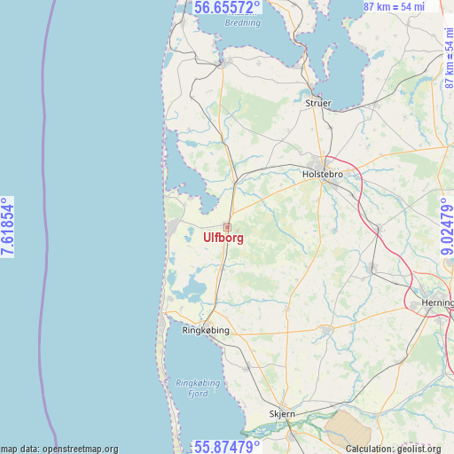
Ulfborg GPS coordinates[2]
56° 16' 2.1" North, 8° 19' 18.012" East
| Map corner | latitude | longitude |
|---|---|---|
| Upper-left | 56.65572°, | 7.61854° |
| Center: | 56.26725°, | 8.32167° |
| Lower-right: | 55.87479°, | 9.02479° |
| Map W x H: | 86.8×86.8 km | = 53.9×53.9mi |
| max Lat: | 57.72093° ⇑20.8% North |
| Ulfborg: | 56.26725° |
| min Lat: | ⇓79.2% South 54.57644° |
| min Long | Ulfborg | max Long |
| 8.12605° | 8.32167° | 15.18662° |
| W 1.8%⇐ | ⇒98.2% E |
Elevation
Elevation of Ulfborg is 18 m = 59 ft, and this is 9.3 m = 31 ft below average elevation for this country.
| Max E: |
114 m = 374 ft | 53.5% |
| Avg. | 27.3 m = 90 ft | |
| Ulfborg | 18 m = 59 ft | |
Min E: |
0 m = 0 ft | 46.5% |
See also: Denmark elevation on elevation.city.
Geographical zone
Ulfborg is located in North temperate zone (between Tropic of Cancer and the Arctic Circle). Distance of this North polar circle is 1144.8 km =711.3 mi to North.| Distance of | km | miles | from Ulfborg |
|---|---|---|---|
| North Pole | 3750.7 | 2330.6 | to North |
| Arctic Circle | 1144.8 | 711.3 | to North |
| Tropic Cancer | 3650.4 | 2268.3 | to South |
| Equator | 6256.3 | 3887.5 | to South |


Nearby cities:
15 places around Ulfborg: (largest is in red/bold)
• Avlum
29.1 km =18.1 mi,  90°
90°
• Harboøre
39.9 km =24.8 mi,  347°
347°
• Herning
43.1 km =26.8 mi,  109°
109°
• Holstebro
20.9 km =13 mi,  60°
60°
• Hvide Sande
32.2 km =20 mi,  202°
202°
• Kibæk
42.3 km =26.3 mi,  128°
128°
• Lemvig
31.3 km =19.4 mi,  358°
358°
• Ringkøbing
20.3 km =12.6 mi,  193°
193°
• Skjern
37 km =23 mi,  162°
162°
• Snejbjerg
39 km =24.2 mi, 112°
• Struer
30.1 km =18.7 mi,  33°
33°
• Tarm
41.9 km =26 mi, 162°
• Videbæk
27.6 km =17.1 mi,  136°
136°
• Vildbjerg
28.5 km =17.7 mi, 105°
• Vinderup
36.9 km =22.9 mi,  49°
49°
Sources, notices
• [Note1] Compared only with cities in Denmark existing in our database
• [Src1] Map data: © OpenStreetMap contributors (CC-BY-SA)
• [Src2] Other city data from geonames.org with taken over terms of usage.
• [Src3] Geographical zone / Annual Mean Temperature by Robert A. Rohde @ Wikipedia
