Holstebro geodata
Holstebro (Central Jutland) is a seat of a second-order administrative division; located in Denmark in Europe/Copenhagen (GMT+2) time zone. With population of 32,072 people, there are 24 cities with bigger population in this country. Compared to other cities in Denmark, 81.3% of cities are located further ↓South; 95.6% of cities are located further →East and 59.6% of cities have higher elevation than Holstebro. Note1


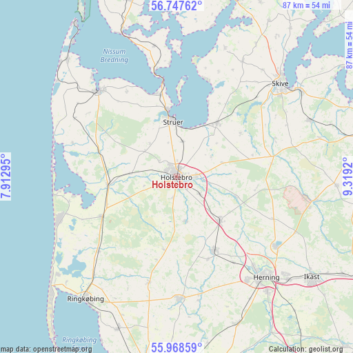
Holstebro GPS coordinates[2]
56° 21' 36.324" North, 8° 36' 57.852" East
| Map corner | latitude | longitude |
|---|---|---|
| Upper-left | 56.74762°, | 7.91295° |
| Center: | 56.36009°, | 8.61607° |
| Lower-right: | 55.96859°, | 9.3192° |
| Map W x H: | 86.6×86.6 km | = 53.8×53.8mi |
| max Lat: | 57.72093° ⇑18.7% North |
| Holstebro: | 56.36009° |
| min Lat: | ⇓81.3% South 54.57644° |
| min Long | Holstebro | max Long |
| 8.12605° | 8.61607° | 15.18662° |
| W 4.4%⇐ | ⇒95.6% E |
Elevation
Elevation of Holstebro is 16 m = 52 ft, and this is 11.3 m = 37 ft below average elevation for this country.
| Max E: |
114 m = 374 ft | 59.6% |
| Avg. | 27.3 m = 90 ft | |
| Holstebro | 16 m = 52 ft | |
Min E: |
0 m = 0 ft | 40.4% |
See also: Denmark elevation on elevation.city.
Geographical zone
Holstebro is located in North temperate zone (between Tropic of Cancer and the Arctic Circle). Distance of this North polar circle is 1134.5 km =704.9 mi to North.| Distance of | km | miles | from Holstebro |
|---|---|---|---|
| North Pole | 3740.4 | 2324.2 | to North |
| Arctic Circle | 1134.5 | 704.9 | to North |
| Tropic Cancer | 3660.7 | 2274.7 | to South |
| Equator | 6266.7 | 3893.9 | to South |


Nearby cities:
15 places around Holstebro: (largest is in red/bold)
• Avlum
15.1 km =9.4 mi,  134°
134°
• Gjellerup
36.1 km =22.4 mi, 131°
• Herning
33.4 km =20.8 mi,  138°
138°
• Karup
34.6 km =21.5 mi,  99°
99°
• Lemvig
28.1 km =17.5 mi,  318°
318°
• Lind
36.1 km =22.4 mi, 141°
• Skive
34.2 km =21.3 mi,  47°
47°
• Snejbjerg
30.9 km =19.2 mi, 144°
• Stoholm
35.4 km =22 mi,  66°
66°
• Struer
14.7 km =9.1 mi,  354°
354°
• Sunds
29.8 km =18.5 mi,  124°
124°
• Ulfborg
20.9 km =13 mi,  240°
240°
• Videbæk
30.3 km =18.8 mi,  178°
178°
• Vildbjerg
20.1 km =12.5 mi,  152°
152°
• Vinderup
16.9 km =10.5 mi,  36°
36°
Sources, notices
• [Note1] Compared only with cities in Denmark existing in our database
• [Src1] Map data: © OpenStreetMap contributors (CC-BY-SA)
• [Src2] Other city data from geonames.org with taken over terms of usage.
• [Src3] Geographical zone / Annual Mean Temperature by Robert A. Rohde @ Wikipedia
