Lemvig geodata
Lemvig (Central Jutland) is a seat of a second-order administrative division; located in Denmark in Europe/Copenhagen (GMT+2) time zone. With population of 7,330 people, there are 100 cities with bigger population in this country. Compared to other cities in Denmark, 85.7% of cities are located further ↓South; 98.5% of cities are located further →East and 89.8% of cities have higher elevation than Lemvig. Note1


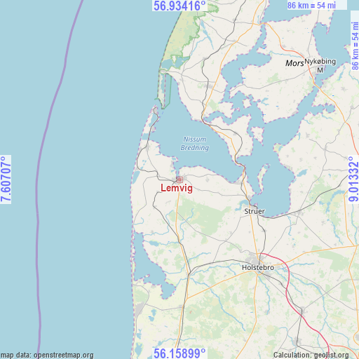
Lemvig GPS coordinates[2]
56° 32' 54.816" North, 8° 18' 36.684" East
| Map corner | latitude | longitude |
|---|---|---|
| Upper-left | 56.93416°, | 7.60707° |
| Center: | 56.54856°, | 8.31019° |
| Lower-right: | 56.15899°, | 9.01332° |
| Map W x H: | 86.2×86.2 km | = 53.6×53.6mi |
| max Lat: | 57.72093° ⇑14.3% North |
| Lemvig: | 56.54856° |
| min Lat: | ⇓85.7% South 54.57644° |
| min Long | Lemvig | max Long |
| 8.12605° | 8.31019° | 15.18662° |
| W 1.5%⇐ | ⇒98.5% E |
Elevation
Elevation of Lemvig is 5 m = 16 ft, and this is 22.3 m = 73 ft below average elevation for this country.
| Max E: |
114 m = 374 ft | 89.8% |
| Avg. | 27.3 m = 90 ft | |
| Lemvig | 5 m = 16 ft | |
Min E: |
0 m = 0 ft | 10.2% |
See also: Denmark elevation on elevation.city.
Geographical zone
Lemvig is located in North temperate zone (between Tropic of Cancer and the Arctic Circle). Distance of this North polar circle is 1113.6 km =692 mi to North.| Distance of | km | miles | from Lemvig |
|---|---|---|---|
| North Pole | 3719.5 | 2311.2 | to North |
| Arctic Circle | 1113.6 | 692 | to North |
| Tropic Cancer | 3681.7 | 2287.7 | to South |
| Equator | 6287.6 | 3906.9 | to South |


Nearby cities:
15 places around Lemvig: (largest is in red/bold)
• Avlum
43.3 km =26.9 mi,  136°
136°
• Harboøre
11 km =6.8 mi,  314°
314°
• Holstebro
28.1 km =17.5 mi, 138°
• Hurup
23.3 km =14.5 mi,  16°
16°
• Nykøbing Mors
42.9 km =26.7 mi,  50°
50°
• Ringkøbing
51.1 km =31.8 mi,  184°
184°
• Skive
44 km =27.3 mi,  87°
87°
• Stoholm
51.8 km =32.2 mi,  97°
97°
• Struer
18.5 km =11.5 mi,  109°
109°
• Thisted
50.9 km =31.6 mi,  27°
27°
• Thyborøn
17.7 km =11 mi,  340°
340°
• Ulfborg
31.3 km =19.4 mi, 178°
• Videbæk
54.9 km =34.1 mi,  159°
159°
• Vildbjerg
47.9 km =29.8 mi, 144°
• Vinderup
29.8 km =18.5 mi, 104°
Sources, notices
• [Note1] Compared only with cities in Denmark existing in our database
• [Src1] Map data: © OpenStreetMap contributors (CC-BY-SA)
• [Src2] Other city data from geonames.org with taken over terms of usage.
• [Src3] Geographical zone / Annual Mean Temperature by Robert A. Rohde @ Wikipedia
