Stubbekøbing geodata
Stubbekøbing (Zealand) is a populated place; located in Denmark in Europe/Copenhagen (GMT+2) time zone. With population of 2,301 people, there are 272 cities with bigger population in this country. Compared to other cities in Denmark, 96.2% of cities are located further ↑North; 77.8% of cities are located further ←West and 83.3% of cities have higher elevation than Stubbekøbing. Note1


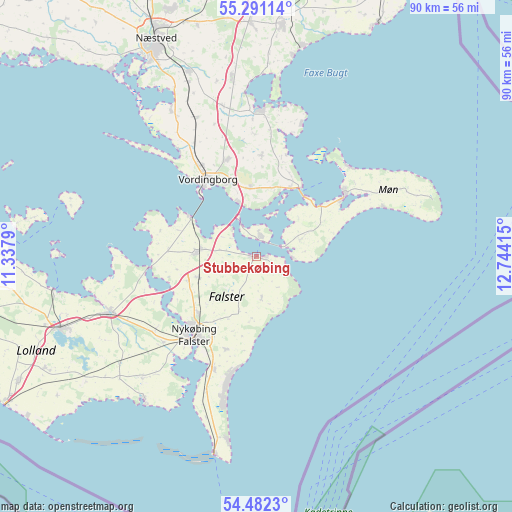
Stubbekøbing GPS coordinates[2]
54° 53' 19.5" North, 12° 2' 27.672" East
| Map corner | latitude | longitude |
|---|---|---|
| Upper-left | 55.29114°, | 11.3379° |
| Center: | 54.88875°, | 12.04102° |
| Lower-right: | 54.4823°, | 12.74415° |
| Map W x H: | 89.9×89.9 km | = 55.9×55.9mi |
| max Lat: | 57.72093° ⇑96.2% North |
| Stubbekøbing: | 54.88875° |
| min Lat: | ⇓3.8% South 54.57644° |
| min Long | Stubbekøbing | max Long |
| 8.12605° | 12.04102° | 15.18662° |
| W 77.8%⇐ | ⇒22.2% E |
Elevation
Elevation of Stubbekøbing is 8 m = 26 ft, and this is 19.3 m = 63 ft below average elevation for this country.
| Max E: |
114 m = 374 ft | 83.3% |
| Avg. | 27.3 m = 90 ft | |
| Stubbekøbing | 8 m = 26 ft | |
Min E: |
0 m = 0 ft | 16.7% |
See also: Denmark elevation on elevation.city.
Geographical zone
Stubbekøbing is located in North temperate zone (between Tropic of Cancer and the Arctic Circle). Distance of this North polar circle is 1298.1 km =806.6 mi to North.| Distance of | km | miles | from Stubbekøbing |
|---|---|---|---|
| North Pole | 3904 | 2425.8 | to North |
| Arctic Circle | 1298.1 | 806.6 | to North |
| Tropic Cancer | 3497.1 | 2173 | to South |
| Equator | 6103.1 | 3792.3 | to South |


Nearby cities:
15 places around Stubbekøbing: (largest is in red/bold)
• Faxe
41.1 km =25.5 mi,  6°
6°
• Faxe Ladeplads
37.7 km =23.4 mi, 12°
• Gedser
35.4 km =22 mi,  191°
191°
• Maribo
36.8 km =22.9 mi,  250°
250°
• Neder Vindinge
18.8 km =11.7 mi,  327°
327°
• Nykøbing Falster
17.1 km =10.6 mi,  218°
218°
• Nyråd
13.9 km =8.6 mi,  338°
338°
• Nørre Alslev
10.1 km =6.3 mi,  275°
275°
• Præstø
26.1 km =16.2 mi,  0°
0°
• Rønnede
41 km =25.5 mi,  358°
358°
• Sakskøbing
28.4 km =17.6 mi, 249°
• Stege
19 km =11.8 mi,  54°
54°
• Sundby
18.2 km =11.3 mi, 222°
• Vordingborg
15.7 km =9.8 mi, 327°
• Ørslev
17.8 km =11.1 mi, 344°
Sources, notices
• [Note1] Compared only with cities in Denmark existing in our database
• [Src1] Map data: © OpenStreetMap contributors (CC-BY-SA)
• [Src2] Other city data from geonames.org with taken over terms of usage.
• [Src3] Geographical zone / Annual Mean Temperature by Robert A. Rohde @ Wikipedia
