Sakskøbing geodata
Sakskøbing (Zealand) is a populated place; located in Denmark in Europe/Copenhagen (GMT+2) time zone. With population of 4,928 people, there are 131 cities with bigger population in this country. Compared to other cities in Denmark, 98% of cities are located further ↑North; 68.7% of cities are located further ←West and 95.6% of cities have higher elevation than Sakskøbing. Note1


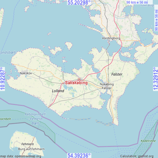
Sakskøbing GPS coordinates[2]
54° 47' 58.92" North, 11° 37' 33.564" East
| Map corner | latitude | longitude |
|---|---|---|
| Upper-left | 55.20298°, | 10.92287° |
| Center: | 54.7997°, | 11.62599° |
| Lower-right: | 54.39236°, | 12.32912° |
| Map W x H: | 90.1×90.1 km | = 56×56mi |
| max Lat: | 57.72093° ⇑98% North |
| Sakskøbing: | 54.7997° |
| min Lat: | ⇓2% South 54.57644° |
| min Long | Sakskøbing | max Long |
| 8.12605° | 11.62599° | 15.18662° |
| W 68.7%⇐ | ⇒31.3% E |
Elevation
Elevation of Sakskøbing is 3 m = 10 ft, and this is 24.3 m = 80 ft below average elevation for this country.
| Max E: |
114 m = 374 ft | 95.6% |
| Avg. | 27.3 m = 90 ft | |
| Sakskøbing | 3 m = 10 ft | |
Min E: |
0 m = 0 ft | 4.4% |
See also: Denmark elevation on elevation.city.
Geographical zone
Sakskøbing is located in North temperate zone (between Tropic of Cancer and the Arctic Circle). Distance of this North polar circle is 1308 km =812.8 mi to North.| Distance of | km | miles | from Sakskøbing |
|---|---|---|---|
| North Pole | 3913.9 | 2432 | to North |
| Arctic Circle | 1308 | 812.8 | to North |
| Tropic Cancer | 3487.2 | 2166.8 | to South |
| Equator | 6093.2 | 3786.1 | to South |


Nearby cities:
15 places around Sakskøbing: (largest is in red/bold)
• Gedser
31.6 km =19.6 mi,  141°
141°
• Holeby
14.3 km =8.9 mi,  226°
226°
• Maribo
8.5 km =5.3 mi,  252°
252°
• Nakskov
31.6 km =19.6 mi,  276°
276°
• Neder Vindinge
30.6 km =19 mi,  32°
32°
• Nykøbing Falster
16.3 km =10.1 mi,  102°
102°
• Nyråd
31.3 km =19.4 mi,  43°
43°
• Nørre Alslev
19.8 km =12.3 mi,  56°
56°
• Præstø
44.9 km =27.9 mi, 36°
• Rødby
19.2 km =11.9 mi, 232°
• Rødbyhavn
23.4 km =14.5 mi, 228°
• Stubbekøbing
28.4 km =17.6 mi,  69°
69°
• Sundby
14.8 km =9.2 mi, 104°
• Vordingborg
29.5 km =18.3 mi, 38°
• Ørslev
34.8 km =21.6 mi, 38°
Sources, notices
• [Note1] Compared only with cities in Denmark existing in our database
• [Src1] Map data: © OpenStreetMap contributors (CC-BY-SA)
• [Src2] Other city data from geonames.org with taken over terms of usage.
• [Src3] Geographical zone / Annual Mean Temperature by Robert A. Rohde @ Wikipedia
