Ry geodata
Ry (Central Jutland) is a populated place; located in Denmark in Europe/Copenhagen (GMT+2) time zone. With population of 4,909 people, there are 132 cities with bigger population in this country. Compared to other cities in Denmark, 70.2% of cities are located further ↓South; 71.1% of cities are located further →East and 71.3% of cities have lower elevation than Ry. Note1


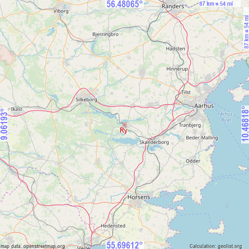
Ry GPS coordinates[2]
56° 5' 25.368" North, 9° 45' 54.18" East
| Map corner | latitude | longitude |
|---|---|---|
| Upper-left | 56.48065°, | 9.06193° |
| Center: | 56.09038°, | 9.76505° |
| Lower-right: | 55.69612°, | 10.46818° |
| Map W x H: | 87.2×87.2 km | = 54.2×54.2mi |
| max Lat: | 57.72093° ⇑29.8% North |
| Ry: | 56.09038° |
| min Lat: | ⇓70.2% South 54.57644° |
| min Long | Ry | max Long |
| 8.12605° | 9.76505° | 15.18662° |
| W 28.9%⇐ | ⇒71.1% E |
Elevation
Elevation of Ry is 38 m = 125 ft, and this is 10.7 m = 35 ft above average elevation for this country.
| Max E: |
114 m = 374 ft | 28.7% |
| Ry | 38 m 125 ft | |
| Avg. | 27.3 m = 90 ft | |
Min E: |
0 m = 0 ft | 71.3% |
See also: Denmark elevation on elevation.city.
Geographical zone
Ry is located in North temperate zone (between Tropic of Cancer and the Arctic Circle). Distance of this North polar circle is 1164.5 km =723.6 mi to North.| Distance of | km | miles | from Ry |
|---|---|---|---|
| North Pole | 3770.4 | 2342.8 | to North |
| Arctic Circle | 1164.5 | 723.6 | to North |
| Tropic Cancer | 3630.7 | 2256 | to South |
| Equator | 6236.7 | 3875.3 | to South |


Nearby cities:
15 places around Ry: (largest is in red/bold)
• Brædstrup
16.3 km =10.1 mi,  215°
215°
• Framlev
17.1 km =10.6 mi,  64°
64°
• Galten
12.1 km =7.5 mi,  50°
50°
• Hammel
19.6 km =12.2 mi,  18°
18°
• Hørning
16.9 km =10.5 mi,  91°
91°
• Kolt
19 km =11.8 mi,  83°
83°
• Sabro
21.6 km =13.4 mi, 50°
• Silkeborg
16.2 km =10.1 mi,  302°
302°
• Skanderborg
12.1 km =7.5 mi,  121°
121°
• Skovby
13.4 km =8.3 mi, 56°
• Solbjerg
20.6 km =12.8 mi,  104°
104°
• Stavtrup
22.5 km =14 mi, 78°
• Stilling
14.2 km =8.8 mi, 102°
• Svejbæk
9.4 km =5.8 mi, 299°
• Virklund
13.8 km =8.6 mi,  289°
289°
Sources, notices
• [Note1] Compared only with cities in Denmark existing in our database
• [Src1] Map data: © OpenStreetMap contributors (CC-BY-SA)
• [Src2] Other city data from geonames.org with taken over terms of usage.
• [Src3] Geographical zone / Annual Mean Temperature by Robert A. Rohde @ Wikipedia
