Rødvig geodata
Rødvig (Zealand) is a populated place; located in Denmark in Europe/Copenhagen (GMT+2) time zone. With population of 1,783 people, there are 323 cities with bigger population in this country. Compared to other cities in Denmark, 84.2% of cities are located further ↑North; 89.8% of cities are located further ←West and 84.5% of cities have higher elevation than Rødvig. Note1


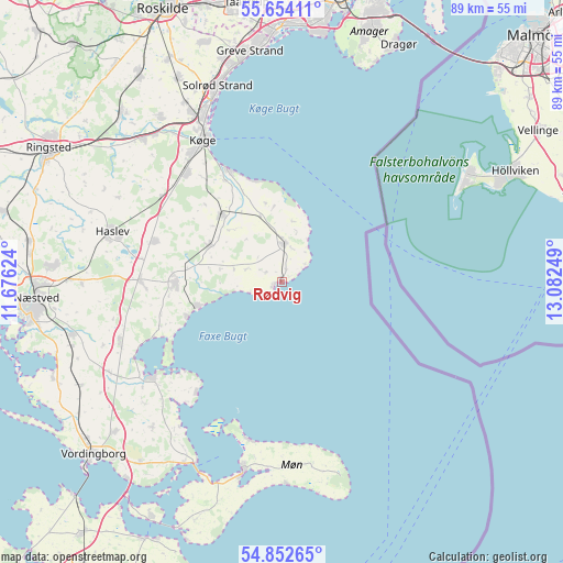
Rødvig GPS coordinates[2]
55° 15' 19.44" North, 12° 22' 45.696" East
| Map corner | latitude | longitude |
|---|---|---|
| Upper-left | 55.65411°, | 11.67624° |
| Center: | 55.2554°, | 12.37936° |
| Lower-right: | 54.85265°, | 13.08249° |
| Map W x H: | 89.1×89.1 km | = 55.4×55.4mi |
| max Lat: | 57.72093° ⇑84.2% North |
| Rødvig: | 55.2554° |
| min Lat: | ⇓15.8% South 54.57644° |
| min Long | Rødvig | max Long |
| 8.12605° | 12.37936° | 15.18662° |
| W 89.8%⇐ | ⇒10.2% E |
Elevation
Elevation of Rødvig is 7 m = 23 ft, and this is 20.3 m = 67 ft below average elevation for this country.
| Max E: |
114 m = 374 ft | 84.5% |
| Avg. | 27.3 m = 90 ft | |
| Rødvig | 7 m = 23 ft | |
Min E: |
0 m = 0 ft | 15.5% |
See also: Denmark elevation on elevation.city.
Geographical zone
Rødvig is located in North temperate zone (between Tropic of Cancer and the Arctic Circle). Distance of this North polar circle is 1257.3 km =781.2 mi to North.| Distance of | km | miles | from Rødvig |
|---|---|---|---|
| North Pole | 3863.2 | 2400.5 | to North |
| Arctic Circle | 1257.3 | 781.2 | to North |
| Tropic Cancer | 3537.9 | 2198.3 | to South |
| Equator | 6143.8 | 3817.6 | to South |


Nearby cities:
15 places around Rødvig: (largest is in red/bold)
• Bjæverskov
31.2 km =19.4 mi,  316°
316°
• Ejby
31.8 km =19.8 mi, 323°
• Faxe
16.5 km =10.3 mi,  270°
270°
• Faxe Ladeplads
13.8 km =8.6 mi,  253°
253°
• Haslev
27.4 km =17 mi,  286°
286°
• Hårlev
13.9 km =8.6 mi, 318°
• Køge
25.7 km =16 mi,  331°
331°
• Præstø
25.8 km =16 mi,  235°
235°
• Rønnede
22.7 km =14.1 mi, 270°
• Solrød
33.6 km =20.9 mi,  338°
338°
• Solrød Strand
32.4 km =20.1 mi, 342°
• Stege
30.4 km =18.9 mi,  191°
191°
• Store Heddinge
6.1 km =3.8 mi,  5°
5°
• Strøby Egede
19.6 km =12.2 mi, 334°
• Ørslev
35.2 km =21.9 mi,  227°
227°
Sources, notices
• [Note1] Compared only with cities in Denmark existing in our database
• [Src1] Map data: © OpenStreetMap contributors (CC-BY-SA)
• [Src2] Other city data from geonames.org with taken over terms of usage.
• [Src3] Geographical zone / Annual Mean Temperature by Robert A. Rohde @ Wikipedia
