Lillerød geodata
Lillerød (Capital Region) is a seat of a second-order administrative division; located in Denmark in Europe/Copenhagen (GMT+2) time zone. With population of 15,359 people, there are 48 cities with bigger population in this country. Compared to other cities in Denmark, 59.6% of cities are located further ↓South; 87.7% of cities are located further ←West and 78.7% of cities have lower elevation than Lillerød. Note1


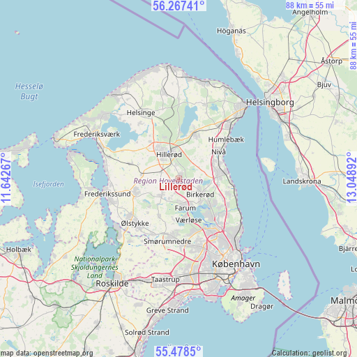
Lillerød GPS coordinates[2]
55° 52' 29.856" North, 12° 20' 44.844" East
| Map corner | latitude | longitude |
|---|---|---|
| Upper-left | 56.26741°, | 11.64267° |
| Center: | 55.87496°, | 12.34579° |
| Lower-right: | 55.4785°, | 13.04892° |
| Map W x H: | 87.7×87.7 km | = 54.5×54.5mi |
| max Lat: | 57.72093° ⇑40.4% North |
| Lillerød: | 55.87496° |
| min Lat: | ⇓59.6% South 54.57644° |
| min Long | Lillerød | max Long |
| 8.12605° | 12.34579° | 15.18662° |
| W 87.7%⇐ | ⇒12.3% E |
Elevation
Elevation of Lillerød is 45 m = 148 ft, and this is 17.7 m = 58 ft above average elevation for this country.
| Max E: |
114 m = 374 ft | 21.3% |
| Lillerød | 45 m 148 ft | |
| Avg. | 27.3 m = 90 ft | |
Min E: |
0 m = 0 ft | 78.7% |
See also: Denmark elevation on elevation.city.
Geographical zone
Lillerød is located in North temperate zone (between Tropic of Cancer and the Arctic Circle). Distance of this North polar circle is 1188.5 km =738.5 mi to North.| Distance of | km | miles | from Lillerød |
|---|---|---|---|
| North Pole | 3794.3 | 2357.7 | to North |
| Arctic Circle | 1188.5 | 738.5 | to North |
| Tropic Cancer | 3606.8 | 2241.2 | to South |
| Equator | 6212.7 | 3860.4 | to South |


Nearby cities:
15 places around Lillerød: (largest is in red/bold)
• Birkerød
6 km =3.7 mi,  120°
120°
• Blovstrød
2.6 km =1.6 mi,  101°
101°
• Farum
7.4 km =4.6 mi,  172°
172°
• Fredensborg
11.7 km =7.3 mi,  17°
17°
• Ganløse
10.6 km =6.6 mi,  208°
208°
• Hillerød
6.5 km =4 mi,  334°
334°
• Holte
9.9 km =6.2 mi,  130°
130°
• Hørsholm
9.7 km =6 mi,  86°
86°
• Kokkedal
10.4 km =6.5 mi,  66°
66°
• Lynge
5.8 km =3.6 mi,  227°
227°
• Nivå
11.9 km =7.4 mi,  56°
56°
• Nødebo
11.5 km =7.1 mi,  0°
0°
• Slangerup
10.5 km =6.5 mi,  254°
254°
• Stavnsholt
7.7 km =4.8 mi,  150°
150°
• Værløse
10.4 km =6.5 mi, 172°
Sources, notices
• [Note1] Compared only with cities in Denmark existing in our database
• [Src1] Map data: © OpenStreetMap contributors (CC-BY-SA)
• [Src2] Other city data from geonames.org with taken over terms of usage.
• [Src3] Geographical zone / Annual Mean Temperature by Robert A. Rohde @ Wikipedia
