Farum geodata
Farum (Capital Region) is a seat of a second-order administrative division; located in Denmark in Europe/Copenhagen (GMT+2) time zone. With population of 18,376 people, there are 43 cities with bigger population in this country. Compared to other cities in Denmark, 55.3% of cities are located further ↓South; 88.6% of cities are located further ←West and 65.8% of cities have lower elevation than Farum. Note1


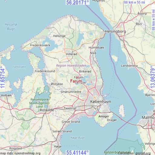
Farum GPS coordinates[2]
55° 48' 30.888" North, 12° 21' 38.376" East
| Map corner | latitude | longitude |
|---|---|---|
| Upper-left | 56.20171°, | 11.65754° |
| Center: | 55.80858°, | 12.36066° |
| Lower-right: | 55.41144°, | 13.06379° |
| Map W x H: | 87.9×87.9 km | = 54.6×54.6mi |
| max Lat: | 57.72093° ⇑44.7% North |
| Farum: | 55.80858° |
| min Lat: | ⇓55.3% South 54.57644° |
| min Long | Farum | max Long |
| 8.12605° | 12.36066° | 15.18662° |
| W 88.6%⇐ | ⇒11.4% E |
Elevation
Elevation of Farum is 33 m = 108 ft, and this is 5.7 m = 19 ft above average elevation for this country.
| Max E: |
114 m = 374 ft | 34.2% |
| Farum | 33 m 108 ft | |
| Avg. | 27.3 m = 90 ft | |
Min E: |
0 m = 0 ft | 65.8% |
See also: Denmark elevation on elevation.city.
Geographical zone
Farum is located in North temperate zone (between Tropic of Cancer and the Arctic Circle). Distance of this North polar circle is 1195.8 km =743 mi to North.| Distance of | km | miles | from Farum |
|---|---|---|---|
| North Pole | 3801.7 | 2362.3 | to North |
| Arctic Circle | 1195.8 | 743 | to North |
| Tropic Cancer | 3599.4 | 2236.6 | to South |
| Equator | 6205.3 | 3855.8 | to South |


Nearby cities:
15 places around Farum: (largest is in red/bold)
• Ballerup
8.6 km =5.3 mi,  178°
178°
• Birkerød
6 km =3.7 mi,  44°
44°
• Blovstrød
7.1 km =4.4 mi,  13°
13°
• Buddinge
10.8 km =6.7 mi,  128°
128°
• Ganløse
6.3 km =3.9 mi,  252°
252°
• Herlev
10.7 km =6.6 mi,  152°
152°
• Holte
6.7 km =4.2 mi,  82°
82°
• Kongens Lyngby
9.9 km =6.2 mi,  115°
115°
• Lillerød
7.4 km =4.6 mi,  352°
352°
• Lynge
6.2 km =3.9 mi,  303°
303°
• Måløv
6.4 km =4 mi,  201°
201°
• Smørumnedre
8.2 km =5.1 mi,  206°
206°
• Stavnsholt
2.9 km =1.8 mi, 76°
• Veksø
9.7 km =6 mi,  231°
231°
• Værløse
2.9 km =1.8 mi,  170°
170°
Sources, notices
• [Note1] Compared only with cities in Denmark existing in our database
• [Src1] Map data: © OpenStreetMap contributors (CC-BY-SA)
• [Src2] Other city data from geonames.org with taken over terms of usage.
• [Src3] Geographical zone / Annual Mean Temperature by Robert A. Rohde @ Wikipedia
