Hørsholm geodata
Hørsholm (Capital Region) is a seat of a second-order administrative division; located in Denmark in Europe/Copenhagen (GMT+2) time zone. With population of 36,670 people, there are 20 cities with bigger population in this country. Compared to other cities in Denmark, 59.9% of cities are located further ↓South; 94.7% of cities are located further ←West and 59.4% of cities have lower elevation than Hørsholm. Note1


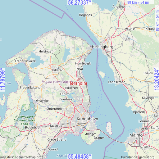
Hørsholm GPS coordinates[2]
55° 52' 51.528" North, 12° 30' 3.996" East
| Map corner | latitude | longitude |
|---|---|---|
| Upper-left | 56.27337°, | 11.79799° |
| Center: | 55.88098°, | 12.50111° |
| Lower-right: | 55.48458°, | 13.20424° |
| Map W x H: | 87.7×87.7 km | = 54.5×54.5mi |
| max Lat: | 57.72093° ⇑40.1% North |
| Hørsholm: | 55.88098° |
| min Lat: | ⇓59.9% South 54.57644° |
| min Long | Hørsholm | max Long |
| 8.12605° | 12.50111° | 15.18662° |
| W 94.7%⇐ | ⇒5.3% E |
Elevation
Elevation of Hørsholm is 29 m = 95 ft, and this is 1.7 m = 6 ft above average elevation for this country.
| Max E: |
114 m = 374 ft | 40.6% |
| Hørsholm | 29 m 95 ft | |
| Avg. | 27.3 m = 90 ft | |
Min E: |
0 m = 0 ft | 59.4% |
See also: Denmark elevation on elevation.city.
Geographical zone
Hørsholm is located in North temperate zone (between Tropic of Cancer and the Arctic Circle). Distance of this North polar circle is 1187.8 km =738.1 mi to North.| Distance of | km | miles | from Hørsholm |
|---|---|---|---|
| North Pole | 3793.7 | 2357.3 | to North |
| Arctic Circle | 1187.8 | 738.1 | to North |
| Tropic Cancer | 3607.5 | 2241.6 | to South |
| Equator | 6213.4 | 3860.8 | to South |


Nearby cities:
15 places around Hørsholm: (largest is in red/bold)
• Birkerød
5.9 km =3.7 mi,  230°
230°
• Blovstrød
7.3 km =4.5 mi,  260°
260°
• Espergærde
13 km =8.1 mi,  12°
12°
• Farum
11.9 km =7.4 mi, 227°
• Fredensborg
12.2 km =7.6 mi,  329°
329°
• Hillerød
13.5 km =8.4 mi,  292°
292°
• Holte
7.5 km =4.7 mi,  196°
196°
• Humlebæk
9.2 km =5.7 mi, 12°
• Kokkedal
3.4 km =2.1 mi,  358°
358°
• Kongens Lyngby
12.3 km =7.6 mi,  179°
179°
• Lillerød
9.7 km =6 mi,  266°
266°
• Nivå
5.9 km =3.7 mi,  2°
2°
• Stavnsholt
9.5 km =5.9 mi,  219°
219°
• Trørød
5.3 km =3.3 mi,  149°
149°
• Værløse
13.7 km =8.5 mi, 217°
Sources, notices
• [Note1] Compared only with cities in Denmark existing in our database
• [Src1] Map data: © OpenStreetMap contributors (CC-BY-SA)
• [Src2] Other city data from geonames.org with taken over terms of usage.
• [Src3] Geographical zone / Annual Mean Temperature by Robert A. Rohde @ Wikipedia
