Frejlev geodata
Frejlev (North Denmark) is a populated place; located in Denmark in Europe/Copenhagen (GMT+2) time zone. With population of 2,286 people, there are 274 cities with bigger population in this country. Compared to other cities in Denmark, 92.1% of cities are located further ↓South; 69.6% of cities are located further →East and 66.7% of cities have lower elevation than Frejlev. Note1


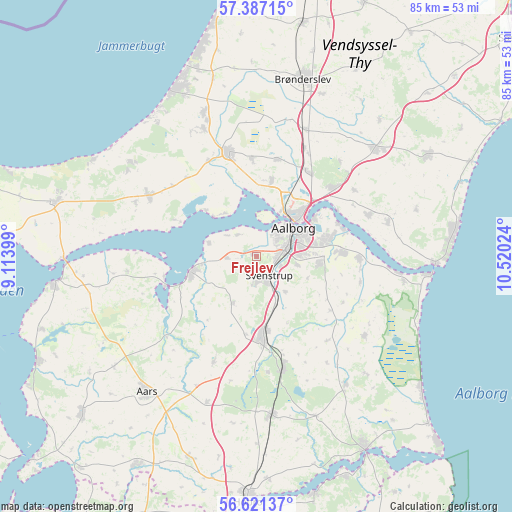
Frejlev GPS coordinates[2]
57° 0' 22.428" North, 9° 49' 1.596" East
| Map corner | latitude | longitude |
|---|---|---|
| Upper-left | 57.38715°, | 9.11399° |
| Center: | 57.00623°, | 9.81711° |
| Lower-right: | 56.62137°, | 10.52024° |
| Map W x H: | 85.1×85.1 km | = 52.9×52.9mi |
| max Lat: | 57.72093° ⇑7.9% North |
| Frejlev: | 57.00623° |
| min Lat: | ⇓92.1% South 54.57644° |
| min Long | Frejlev | max Long |
| 8.12605° | 9.81711° | 15.18662° |
| W 30.4%⇐ | ⇒69.6% E |
Elevation
Elevation of Frejlev is 34 m = 112 ft, and this is 6.7 m = 22 ft above average elevation for this country.
| Max E: |
114 m = 374 ft | 33.3% |
| Frejlev | 34 m 112 ft | |
| Avg. | 27.3 m = 90 ft | |
Min E: |
0 m = 0 ft | 66.7% |
See also: Denmark elevation on elevation.city.
Geographical zone
Frejlev is located in North temperate zone (between Tropic of Cancer and the Arctic Circle). Distance of this North polar circle is 1062.7 km =660.3 mi to North.| Distance of | km | miles | from Frejlev |
|---|---|---|---|
| North Pole | 3668.6 | 2279.6 | to North |
| Arctic Circle | 1062.7 | 660.3 | to North |
| Tropic Cancer | 3732.6 | 2319.3 | to South |
| Equator | 6338.5 | 3938.6 | to South |


Nearby cities:
15 places around Frejlev: (largest is in red/bold)
• Aalborg
7.7 km =4.8 mi,  52°
52°
• Brovst
20.5 km =12.7 mi,  299°
299°
• Gistrup
10.6 km =6.6 mi,  97°
97°
• Klarup
14.5 km =9 mi,  87°
87°
• Nibe
11.1 km =6.9 mi,  255°
255°
• Nørresundby
8.7 km =5.4 mi, 47°
• Skørping
19.4 km =12.1 mi,  166°
166°
• Storvorde
17.2 km =10.7 mi, 90°
• Støvring
13.5 km =8.4 mi, 174°
• Svenstrup
4.2 km =2.6 mi,  153°
153°
• Vadum
12.6 km =7.8 mi,  10°
10°
• Vestbjerg
16.4 km =10.2 mi,  31°
31°
• Vester Hassing
19.9 km =12.4 mi,  69°
69°
• Vodskov
16.8 km =10.4 mi, 47°
• Åbybro
18.2 km =11.3 mi,  343°
343°
Sources, notices
• [Note1] Compared only with cities in Denmark existing in our database
• [Src1] Map data: © OpenStreetMap contributors (CC-BY-SA)
• [Src2] Other city data from geonames.org with taken over terms of usage.
• [Src3] Geographical zone / Annual Mean Temperature by Robert A. Rohde @ Wikipedia
