Vester Hassing geodata
Vester Hassing (North Denmark) is a populated place; located in Denmark in Europe/Copenhagen (GMT+2) time zone. With population of 2,298 people, there are 273 cities with bigger population in this country. Compared to other cities in Denmark, 93.3% of cities are located further ↓South; 54.4% of cities are located further →East and 59.6% of cities have higher elevation than Vester Hassing. Note1


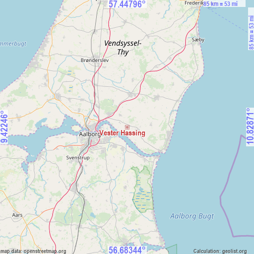
Vester Hassing GPS coordinates[2]
57° 4' 3.612" North, 10° 7' 32.088" East
| Map corner | latitude | longitude |
|---|---|---|
| Upper-left | 57.44796°, | 9.42246° |
| Center: | 57.06767°, | 10.12558° |
| Lower-right: | 56.68344°, | 10.82871° |
| Map W x H: | 85×85 km | = 52.8×52.8mi |
| max Lat: | 57.72093° ⇑6.7% North |
| Vester Hassing: | 57.06767° |
| min Lat: | ⇓93.3% South 54.57644° |
| min Long | Vester Hassing | max Long |
| 8.12605° | 10.12558° | 15.18662° |
| W 45.6%⇐ | ⇒54.4% E |
Elevation
Elevation of Vester Hassing is 16 m = 52 ft, and this is 11.3 m = 37 ft below average elevation for this country.
| Max E: |
114 m = 374 ft | 59.6% |
| Avg. | 27.3 m = 90 ft | |
| Vester Hassing | 16 m = 52 ft | |
Min E: |
0 m = 0 ft | 40.4% |
See also: Denmark elevation on elevation.city.
Geographical zone
Vester Hassing is located in North temperate zone (between Tropic of Cancer and the Arctic Circle). Distance of this North polar circle is 1055.8 km =656 mi to North.| Distance of | km | miles | from Vester Hassing |
|---|---|---|---|
| North Pole | 3661.7 | 2275.3 | to North |
| Arctic Circle | 1055.8 | 656 | to North |
| Tropic Cancer | 3739.4 | 2323.6 | to South |
| Equator | 6345.3 | 3942.8 | to South |


Nearby cities:
15 places around Vester Hassing: (largest is in red/bold)
• Aalborg
12.7 km =7.9 mi,  260°
260°
• Brønderslev
25.1 km =15.6 mi,  333°
333°
• Dronninglund
14.4 km =8.9 mi,  44°
44°
• Frejlev
19.9 km =12.4 mi,  249°
249°
• Gistrup
11.5 km =7.1 mi,  224°
224°
• Hals
13.6 km =8.5 mi,  125°
125°
• Hjallerup
10.9 km =6.8 mi,  6°
6°
• Klarup
7.5 km =4.7 mi,  214°
214°
• Nørresundby
12.3 km =7.6 mi,  265°
265°
• Storvorde
7.2 km =4.5 mi,  191°
191°
• Svenstrup
19.9 km =12.4 mi,  237°
237°
• Vadum
17.2 km =10.7 mi,  288°
288°
• Vestbjerg
12.3 km =7.6 mi,  305°
305°
• Vodskov
7.7 km =4.8 mi, 306°
• Åbybro
26.1 km =16.2 mi, 293°
Sources, notices
• [Note1] Compared only with cities in Denmark existing in our database
• [Src1] Map data: © OpenStreetMap contributors (CC-BY-SA)
• [Src2] Other city data from geonames.org with taken over terms of usage.
• [Src3] Geographical zone / Annual Mean Temperature by Robert A. Rohde @ Wikipedia
