Åbybro geodata
Åbybro (North Denmark) is a seat of a second-order administrative division; located in Denmark in Europe/Copenhagen (GMT+2) time zone. With population of 4,849 people, there are 135 cities with bigger population in this country. Compared to other cities in Denmark, 95.6% of cities are located further ↓South; 72.5% of cities are located further →East and 85.7% of cities have higher elevation than Åbybro. Note1


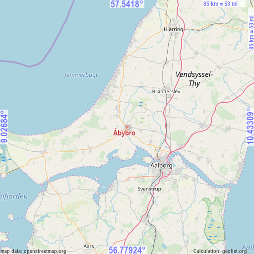
Åbybro GPS coordinates[2]
57° 9' 44.964" North, 9° 43' 47.856" East
| Map corner | latitude | longitude |
|---|---|---|
| Upper-left | 57.5418°, | 9.02684° |
| Center: | 57.16249°, | 9.72996° |
| Lower-right: | 56.77924°, | 10.43309° |
| Map W x H: | 84.8×84.8 km | = 52.7×52.7mi |
| max Lat: | 57.72093° ⇑4.4% North |
| Åbybro: | 57.16249° |
| min Lat: | ⇓95.6% South 54.57644° |
| min Long | Åbybro | max Long |
| 8.12605° | 9.72996° | 15.18662° |
| W 27.5%⇐ | ⇒72.5% E |
Elevation
Elevation of Åbybro is 6 m = 20 ft, and this is 21.3 m = 70 ft below average elevation for this country.
| Max E: |
114 m = 374 ft | 85.7% |
| Avg. | 27.3 m = 90 ft | |
| Åbybro | 6 m = 20 ft | |
Min E: |
0 m = 0 ft | 14.3% |
See also: Denmark elevation on elevation.city.
Geographical zone
Åbybro is located in North temperate zone (between Tropic of Cancer and the Arctic Circle). Distance of this North polar circle is 1045.3 km =649.5 mi to North.| Distance of | km | miles | from Åbybro |
|---|---|---|---|
| North Pole | 3651.2 | 2268.7 | to North |
| Arctic Circle | 1045.3 | 649.5 | to North |
| Tropic Cancer | 3750 | 2330.1 | to South |
| Equator | 6355.9 | 3949.4 | to South |


Nearby cities:
15 places around Åbybro: (largest is in red/bold)
• Aalborg
17.1 km =10.6 mi,  138°
138°
• Brovst
14.4 km =8.9 mi,  239°
239°
• Brønderslev
17.5 km =10.9 mi,  46°
46°
• Frejlev
18.2 km =11.3 mi,  163°
163°
• Gistrup
24.5 km =15.2 mi, 139°
• Kås
5.3 km =3.3 mi,  318°
318°
• Løkken
23.1 km =14.4 mi,  357°
357°
• Nibe
20.9 km =13 mi,  195°
195°
• Nørresundby
16.4 km =10.2 mi,  134°
134°
• Pandrup
7.3 km =4.5 mi,  333°
333°
• Svenstrup
22.3 km =13.9 mi, 161°
• Vadum
9.1 km =5.7 mi,  122°
122°
• Vestbjerg
14.3 km =8.9 mi,  103°
103°
• Vodskov
18.6 km =11.6 mi,  108°
108°
• Vrå
24.8 km =15.4 mi,  30°
30°
Sources, notices
• [Note1] Compared only with cities in Denmark existing in our database
• [Src1] Map data: © OpenStreetMap contributors (CC-BY-SA)
• [Src2] Other city data from geonames.org with taken over terms of usage.
• [Src3] Geographical zone / Annual Mean Temperature by Robert A. Rohde @ Wikipedia
