Borup geodata
Borup (Zealand) is a populated place; located in Denmark in Europe/Copenhagen (GMT+2) time zone. With population of 3,120 people, there are 202 cities with bigger population in this country. Compared to other cities in Denmark, 67.5% of cities are located further ↑North; 75.7% of cities are located further ←West and 78.1% of cities have lower elevation than Borup. Note1


Borup GPS coordinates[2]
55° 29' 40.992" North, 11° 58' 33.024" East
| Map corner | latitude | longitude |
|---|---|---|
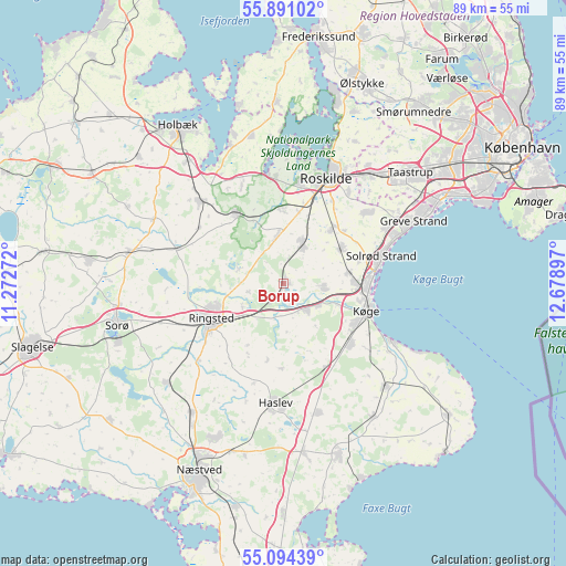
| Upper-left | 55.89102°, | 11.27272° |
| Center: | 55.49472°, | 11.97584° |
| Lower-right: | 55.09439°, | 12.67897° |
| Map W x H: | 88.6×88.6 km | = 55.1×55.1mi |
| max Lat: | 57.72093° ⇑67.5% North |
| Borup: | 55.49472° |
| min Lat: | ⇓32.5% South 54.57644° |
| min Long | Borup | max Long |
| 8.12605° | 11.97584° | 15.18662° |
| W 75.7%⇐ | ⇒24.3% E |
Elevation
Elevation of Borup is 44 m = 144 ft, and this is 16.7 m = 55 ft above average elevation for this country.
| Max E: |
114 m = 374 ft | 21.9% |
| Borup | 44 m 144 ft | |
| Avg. | 27.3 m = 90 ft | |
Min E: |
0 m = 0 ft | 78.1% |
See also: Denmark elevation on elevation.city.
Geographical zone
Borup is located in North temperate zone (between Tropic of Cancer and the Arctic Circle). Distance of this North polar circle is 1230.7 km =764.7 mi to North.| Distance of | km | miles | from Borup |
|---|---|---|---|
| North Pole | 3836.6 | 2384 | to North |
| Arctic Circle | 1230.7 | 764.7 | to North |
| Tropic Cancer | 3564.5 | 2214.9 | to South |
| Equator | 6170.4 | 3834.1 | to South |


Nearby cities:
15 places around Borup: (largest is in red/bold)
• Bjæverskov
5.6 km =3.5 mi,  137°
137°
• Ejby
6.7 km =4.2 mi,  98°
98°
• Havdrup
10.9 km =6.8 mi,  59°
59°
• Kirke Hvalsø
12.9 km =8 mi,  326°
326°
• Køge
13.6 km =8.5 mi,  107°
107°
• Lejre
12.2 km =7.6 mi,  359°
359°
• Osted
7.6 km =4.7 mi,  351°
351°
• Ringsted
13.1 km =8.1 mi,  243°
243°
• Roskilde
17.6 km =10.9 mi,  21°
21°
• Solrød
13.8 km =8.6 mi,  70°
70°
• Solrød Strand
16.1 km =10 mi, 74°
• Svogerslev
15.7 km =9.8 mi,  8°
8°
• Tune
16.4 km =10.2 mi,  48°
48°
• Viby
6.7 km =4.2 mi,  26°
26°
• Vindinge
17.6 km =10.9 mi,  35°
35°
Sources, notices
• [Note1] Compared only with cities in Denmark existing in our database
• [Src1] Map data: © OpenStreetMap contributors (CC-BY-SA)
• [Src2] Other city data from geonames.org with taken over terms of usage.
• [Src3] Geographical zone / Annual Mean Temperature by Robert A. Rohde @ Wikipedia
