Kirke Hvalsø geodata
Kirke Hvalsø (Zealand) is a seat of a second-order administrative division; located in Denmark in Europe/Copenhagen (GMT+2) time zone. With population of 4,086 people, there are 156 cities with bigger population in this country. Compared to other cities in Denmark, 62% of cities are located further ↑North; 71.9% of cities are located further ←West and 88.9% of cities have lower elevation than Kirke Hvalsø. Note1


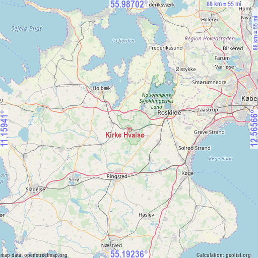
Kirke Hvalsø GPS coordinates[2]
55° 35' 30.12" North, 11° 51' 45.108" East
| Map corner | latitude | longitude |
|---|---|---|
| Upper-left | 55.98702°, | 11.15941° |
| Center: | 55.5917°, | 11.86253° |
| Lower-right: | 55.19236°, | 12.56566° |
| Map W x H: | 88.4×88.4 km | = 54.9×54.9mi |
| max Lat: | 57.72093° ⇑62% North |
| Kirke Hvalsø: | 55.5917° |
| min Lat: | ⇓38% South 54.57644° |
| min Long | Kirke Hvalsø | max Long |
| 8.12605° | 11.86253° | 15.18662° |
| W 71.9%⇐ | ⇒28.1% E |
Elevation
Elevation of Kirke Hvalsø is 56 m = 184 ft, and this is 28.7 m = 94 ft above average elevation for this country.
| Max E: |
114 m = 374 ft | 11.1% |
| Kirke Hvalsø | 56 m 184 ft | |
| Avg. | 27.3 m = 90 ft | |
Min E: |
0 m = 0 ft | 88.9% |
See also: Denmark elevation on elevation.city.
Geographical zone
Kirke Hvalsø is located in North temperate zone (between Tropic of Cancer and the Arctic Circle). Distance of this North polar circle is 1220 km =758.1 mi to North.| Distance of | km | miles | from Kirke Hvalsø |
|---|---|---|---|
| North Pole | 3825.8 | 2377.2 | to North |
| Arctic Circle | 1220 | 758.1 | to North |
| Tropic Cancer | 3575.3 | 2221.6 | to South |
| Equator | 6181.2 | 3840.8 | to South |


Nearby cities:
15 places around Kirke Hvalsø: (largest is in red/bold)
• Borup
12.9 km =8 mi,  146°
146°
• Ejby
10.9 km =6.8 mi,  354°
354°
• Ejby
18.1 km =11.2 mi,  130°
130°
• Havdrup
17.2 km =10.7 mi,  107°
107°
• Holbæk
16.8 km =10.4 mi,  326°
326°
• Lejre
7.2 km =4.5 mi,  78°
78°
• Osted
6.8 km =4.2 mi,  118°
118°
• Ringsted
17.2 km =10.7 mi,  195°
195°
• Roskilde
14.8 km =9.2 mi,  67°
67°
• Stenlille
18 km =11.2 mi,  251°
251°
• Svogerslev
10.7 km =6.6 mi,  63°
63°
• Tølløse
6.2 km =3.9 mi,  291°
291°
• Viby
11.2 km =7 mi, 115°
• Vindinge
17.7 km =11 mi, 78°
• Vipperød
11.4 km =7.1 mi,  317°
317°
Sources, notices
• [Note1] Compared only with cities in Denmark existing in our database
• [Src1] Map data: © OpenStreetMap contributors (CC-BY-SA)
• [Src2] Other city data from geonames.org with taken over terms of usage.
• [Src3] Geographical zone / Annual Mean Temperature by Robert A. Rohde @ Wikipedia
