Ringsted geodata
Ringsted (Zealand) is a seat of a second-order administrative division; located in Denmark in Europe/Copenhagen (GMT+2) time zone. With population of 20,188 people, there are 39 cities with bigger population in this country. Compared to other cities in Denmark, 73.1% of cities are located further ↑North; 70.5% of cities are located further ←West and 87.1% of cities have lower elevation than Ringsted. Note1


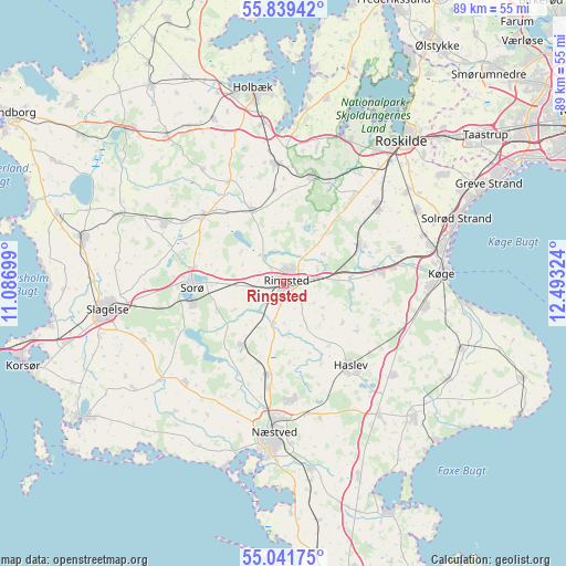
Ringsted GPS coordinates[2]
55° 26' 33.36" North, 11° 47' 24.396" East
| Map corner | latitude | longitude |
|---|---|---|
| Upper-left | 55.83942°, | 11.08699° |
| Center: | 55.4426°, | 11.79011° |
| Lower-right: | 55.04175°, | 12.49324° |
| Map W x H: | 88.7×88.7 km | = 55.1×55.1mi |
| max Lat: | 57.72093° ⇑73.1% North |
| Ringsted: | 55.4426° |
| min Lat: | ⇓26.9% South 54.57644° |
| min Long | Ringsted | max Long |
| 8.12605° | 11.79011° | 15.18662° |
| W 70.5%⇐ | ⇒29.5% E |
Elevation
Elevation of Ringsted is 54 m = 177 ft, and this is 26.7 m = 88 ft above average elevation for this country.
| Max E: |
114 m = 374 ft | 12.9% |
| Ringsted | 54 m 177 ft | |
| Avg. | 27.3 m = 90 ft | |
Min E: |
0 m = 0 ft | 87.1% |
See also: Denmark elevation on elevation.city.
Geographical zone
Ringsted is located in North temperate zone (between Tropic of Cancer and the Arctic Circle). Distance of this North polar circle is 1236.5 km =768.3 mi to North.| Distance of | km | miles | from Ringsted |
|---|---|---|---|
| North Pole | 3842.4 | 2387.6 | to North |
| Arctic Circle | 1236.5 | 768.3 | to North |
| Tropic Cancer | 3558.7 | 2211.3 | to South |
| Equator | 6164.6 | 3830.5 | to South |


Nearby cities:
15 places around Ringsted: (largest is in red/bold)
• Bjæverskov
15.6 km =9.7 mi,  83°
83°
• Borup
13.1 km =8.1 mi,  63°
63°
• Dianalund
21.2 km =13.2 mi,  297°
297°
• Ejby
19 km =11.8 mi, 75°
• Fensmark
18.2 km =11.3 mi,  177°
177°
• Frederiksberg
14.2 km =8.8 mi,  258°
258°
• Fuglebjerg
21.6 km =13.4 mi,  225°
225°
• Haslev
17.2 km =10.7 mi,  140°
140°
• Kirke Hvalsø
17.2 km =10.7 mi,  15°
15°
• Lejre
21.4 km =13.3 mi,  32°
32°
• Osted
17 km =10.6 mi,  38°
38°
• Sorø
14.8 km =9.2 mi,  265°
265°
• Stenlille
16.5 km =10.3 mi,  310°
310°
• Tølløse
18.9 km =11.7 mi,  356°
356°
• Viby
18.9 km =11.7 mi,  51°
51°
Sources, notices
• [Note1] Compared only with cities in Denmark existing in our database
• [Src1] Map data: © OpenStreetMap contributors (CC-BY-SA)
• [Src2] Other city data from geonames.org with taken over terms of usage.
• [Src3] Geographical zone / Annual Mean Temperature by Robert A. Rohde @ Wikipedia
