Rosalie geodata
Rosalie (Saint David) is a seat of a first-order administrative division; located in Dominica in America/Dominica (GMT-4) time zone. With population of 802 people, there are 15 cities with bigger population in this country. Compared to other cities in Dominica, 58.8% of cities are located further ↑North; 88.2% of cities are located further ←West and 70.6% of cities have lower elevation than Rosalie. Note1


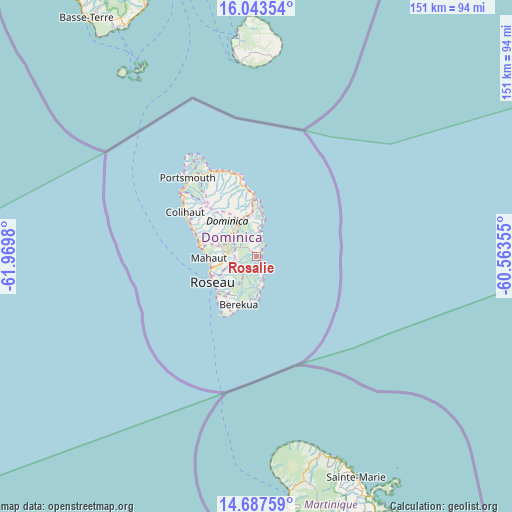
Rosalie GPS coordinates[2]
15° 22' 0.012" North, 61° 16' 0.012" West
| Map corner | latitude | longitude |
|---|---|---|
| Upper-left | 16.04354°, | -61.9698° |
| Center: | 15.36667°, | -61.26667° |
| Lower-right: | 14.68759°, | -60.56355° |
| Map W x H: | 150.8×150.8 km | = 93.7×93.7mi |
| max Lat: | 15.59297° ⇑58.8% North |
| Rosalie: | 15.36667° |
| min Lat: | ⇓41.2% South 15.23333° |
| min Long | Rosalie | max Long |
| -61.46667° | -61.26667° | -61.24753° |
| W 88.2%⇐ | ⇒11.8% E |
Elevation
Elevation of Rosalie is 75 m = 246 ft, and this is 5.1 m = 17 ft below average elevation for this country.
| Max E: |
595 m = 1952 ft | 29.4% |
| Avg. | 80.1 m = 263 ft | |
| Rosalie | 75 m = 246 ft | |
Min E: |
1 m = 3 ft | 70.6% |
See also: Dominica elevation on elevation.city.
Geographical zone
Rosalie is located in North Torrid zone (between Equator and Tropic of Cancer). Distance of this Northern Tropic circle is 897.3 km =557.6 mi to North.| Distance of | km | miles | from Rosalie |
|---|---|---|---|
| North Pole | 8298.4 | 5156.4 | to North |
| Arctic Circle | 5692.6 | 3537.2 | to North |
| Tropic Cancer | 897.3 | 557.6 | to North |
| Equator | 1708.6 | 1061.7 | to South |


Nearby cities:
15 places around Rosalie: (largest is in red/bold)
• Berekua
15.8 km =9.8 mi,  199°
199°
• Castle Bruce
8.7 km =5.4 mi,  6°
6°
• Castle Comfort
14.4 km =8.9 mi,  230°
230°
• Colihaut
24.7 km =15.3 mi,  302°
302°
• La Plaine
4.8 km =3 mi,  154°
154°
• Mahaut
14 km =8.7 mi,  268°
268°
• Marigot
19.2 km =11.9 mi,  354°
354°
• Pointe Michel
16.6 km =10.3 mi,  224°
224°
• Pont Cassé
8.9 km =5.5 mi, 270°
• Roseau
14.9 km =9.3 mi,  240°
240°
• Saint Joseph
18.2 km =11.3 mi,  281°
281°
• Salisbury
19.8 km =12.3 mi,  293°
293°
• Soufrière
17.8 km =11.1 mi,  213°
213°
• Wesley
22.9 km =14.2 mi, 346°
• Woodford Hill
24.8 km =15.4 mi,  343°
343°
Sources, notices
• [Note1] Compared only with cities in Dominica existing in our database
• [Src1] Map data: © OpenStreetMap contributors (CC-BY-SA)
• [Src2] Other city data from geonames.org with taken over terms of usage.
• [Src3] Geographical zone / Annual Mean Temperature by Robert A. Rohde @ Wikipedia
