Castle Comfort geodata
Castle Comfort (Saint George) is a populated place; located in Dominica in America/Dominica (GMT-4) time zone. With population of 790 people, there are 16 cities with bigger population in this country. Compared to other cities in Dominica, 82.4% of cities are located further ↑North; 58.8% of cities are located further →East and 88.2% of cities have lower elevation than Castle Comfort. Note1


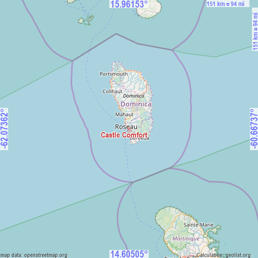
Castle Comfort GPS coordinates[2]
15° 17' 3.804" North, 61° 22' 13.764" West
| Map corner | latitude | longitude |
|---|---|---|
| Upper-left | 15.96153°, | -62.07362° |
| Center: | 15.28439°, | -61.37049° |
| Lower-right: | 14.60505°, | -60.66737° |
| Map W x H: | 150.8×150.8 km | = 93.7×93.7mi |
| max Lat: | 15.59297° ⇑82.4% North |
| Castle Comfort: | 15.28439° |
| min Lat: | ⇓17.6% South 15.23333° |
| min Long | Castle Comfort | max Long |
| -61.46667° | -61.37049° | -61.24753° |
| W 41.2%⇐ | ⇒58.8% E |
Elevation
Elevation of Castle Comfort is 91 m = 299 ft, and this is 10.9 m = 36 ft above average elevation for this country.
| Max E: |
595 m = 1952 ft | 11.8% |
| Castle Comfort | 91 m 299 ft | |
| Avg. | 80.1 m = 263 ft | |
Min E: |
1 m = 3 ft | 88.2% |
See also: Dominica elevation on elevation.city.
Geographical zone
Castle Comfort is located in North Torrid zone (between Equator and Tropic of Cancer). Distance of this Northern Tropic circle is 906.5 km =563.3 mi to North.| Distance of | km | miles | from Castle Comfort |
|---|---|---|---|
| North Pole | 8307.6 | 5162.1 | to North |
| Arctic Circle | 5701.7 | 3542.9 | to North |
| Tropic Cancer | 906.5 | 563.3 | to North |
| Equator | 1699.5 | 1056 | to South |


Nearby cities:
15 places around Castle Comfort: (largest is in red/bold)
• Berekua
8.1 km =5 mi,  134°
134°
• Castle Bruce
21.5 km =13.4 mi,  34°
34°
• Colihaut
24.4 km =15.2 mi,  336°
336°
• La Plaine
14 km =8.7 mi,  69°
69°
• Mahaut
9.3 km =5.8 mi, 342°
• Marigot
29.8 km =18.5 mi,  18°
18°
• Pointe Michel
2.8 km =1.7 mi,  188°
188°
• Pont Cassé
9.4 km =5.8 mi,  13°
13°
• Rosalie
14.4 km =8.9 mi,  50°
50°
• Roseau
2.7 km =1.7 mi,  315°
315°
• Saint Joseph
14.5 km =9 mi,  332°
332°
• Salisbury
18.4 km =11.4 mi, 337°
• Soufrière
5.8 km =3.6 mi,  167°
167°
• Wesley
31.9 km =19.8 mi, 10°
• Woodford Hill
33.2 km =20.6 mi, 7°
Sources, notices
• [Note1] Compared only with cities in Dominica existing in our database
• [Src1] Map data: © OpenStreetMap contributors (CC-BY-SA)
• [Src2] Other city data from geonames.org with taken over terms of usage.
• [Src3] Geographical zone / Annual Mean Temperature by Robert A. Rohde @ Wikipedia
