Castle Bruce geodata
Castle Bruce (Saint David) is a populated place; located in Dominica in America/Dominica (GMT-4) time zone. With population of 1,387 people, there are 9 cities with bigger population in this country. Compared to other cities in Dominica, 64.7% of cities are located further ↓South; 94.1% of cities are located further ←West and 64.7% of cities have lower elevation than Castle Bruce. Note1


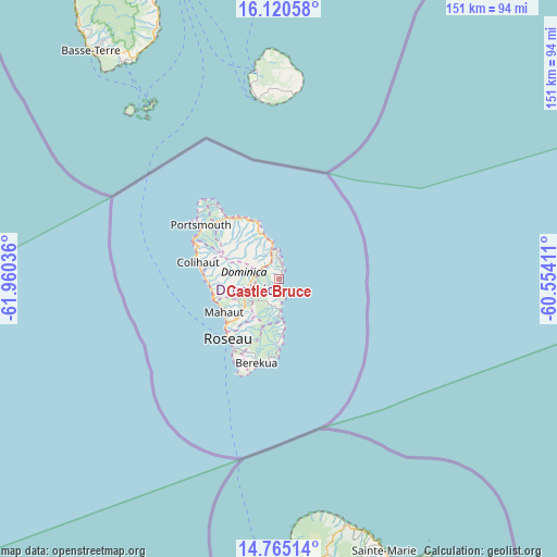
Castle Bruce GPS coordinates[2]
15° 26' 38.292" North, 61° 15' 26.028" West
| Map corner | latitude | longitude |
|---|---|---|
| Upper-left | 16.12058°, | -61.96036° |
| Center: | 15.44397°, | -61.25723° |
| Lower-right: | 14.76514°, | -60.55411° |
| Map W x H: | 150.7×150.7 km | = 93.6×93.6mi |
| max Lat: | 15.59297° ⇑35.3% North |
| Castle Bruce: | 15.44397° |
| min Lat: | ⇓64.7% South 15.23333° |
| min Long | Castle Bruce | max Long |
| -61.46667° | -61.25723° | -61.24753° |
| W 94.1%⇐ | ⇒5.9% E |
Elevation
Elevation of Castle Bruce is 60 m = 197 ft, and this is 20.1 m = 66 ft below average elevation for this country.
| Max E: |
595 m = 1952 ft | 35.3% |
| Avg. | 80.1 m = 263 ft | |
| Castle Bruce | 60 m = 197 ft | |
Min E: |
1 m = 3 ft | 64.7% |
See also: Dominica elevation on elevation.city.
Geographical zone
Castle Bruce is located in North Torrid zone (between Equator and Tropic of Cancer). Distance of this Northern Tropic circle is 888.7 km =552.2 mi to North.| Distance of | km | miles | from Castle Bruce |
|---|---|---|---|
| North Pole | 8289.9 | 5151.1 | to North |
| Arctic Circle | 5684 | 3531.9 | to North |
| Tropic Cancer | 888.7 | 552.2 | to North |
| Equator | 1717.2 | 1067 | to South |


Nearby cities:
15 places around Castle Bruce: (largest is in red/bold)
• Berekua
24.3 km =15.1 mi,  195°
195°
• Calibishie
19.3 km =12 mi,  329°
329°
• Castle Comfort
21.5 km =13.4 mi,  214°
214°
• Colihaut
22.4 km =13.9 mi,  281°
281°
• La Plaine
13 km =8.1 mi,  175°
175°
• Mahaut
17.4 km =10.8 mi,  239°
239°
• Marigot
10.9 km =6.8 mi,  344°
344°
• Pointe Michel
24 km =14.9 mi, 211°
• Pont Cassé
13.1 km =8.1 mi,  229°
229°
• Rosalie
8.7 km =5.4 mi,  186°
186°
• Roseau
21.1 km =13.1 mi,  221°
221°
• Saint Joseph
19.5 km =12.1 mi,  255°
255°
• Salisbury
19.2 km =11.9 mi,  267°
267°
• Wesley
15.1 km =9.4 mi, 334°
• Woodford Hill
17.2 km =10.7 mi, 332°
Sources, notices
• [Note1] Compared only with cities in Dominica existing in our database
• [Src1] Map data: © OpenStreetMap contributors (CC-BY-SA)
• [Src2] Other city data from geonames.org with taken over terms of usage.
• [Src3] Geographical zone / Annual Mean Temperature by Robert A. Rohde @ Wikipedia
