Paya geodata
Paya (Peravia) is a populated place; located in Dominican Republic in America/Santo_Domingo (GMT-4) time zone. With population of 6,916 people, there are 85 cities with bigger population in this country. Compared to other cities in Dominican Republic, 94.3% of cities are located further ↑North; 64.5% of cities are located further ←West and 62.1% of cities have higher elevation than Paya. Note1
Administrative division(s):
- Level 1: Peravia
- Level 2: Baní
- Level 3: Paya (D. M.).
- Level 4: Paya (Zona Urbana)


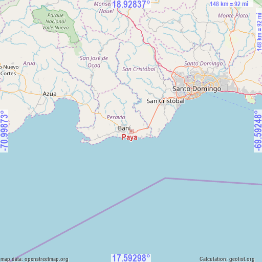
Paya GPS coordinates[2]
18° 15' 43.056" North, 70° 17' 44.16" West
| Map corner | latitude | longitude |
|---|---|---|
| Upper-left | 18.92837°, | -70.99873° |
| Center: | 18.26196°, | -70.2956° |
| Lower-right: | 17.59298°, | -69.59248° |
| Map W x H: | 148.5×148.5 km | = 92.3×92.3mi |
| max Lat: | 19.89131° ⇑94.3% North |
| Paya: | 18.26196° |
| min Lat: | ⇓5.7% South 17.80136° |
| min Long | Paya | max Long |
| -71.85022° | -70.2956° | -68.40431° |
| W 64.5%⇐ | ⇒35.5% E |
Elevation
Elevation of Paya is 47 m = 154 ft, and this is 119.3 m = 391 ft below average elevation for this country.
| Max E: |
1242 m = 4075 ft | 62.1% |
| Avg. | 166.3 m = 546 ft | |
| Paya | 47 m = 154 ft | |
Min E: |
5 m = 16 ft | 37.9% |
See also: Dominican Republic elevation on elevation.city.
Geographical zone
Paya is located in North Torrid zone (between Equator and Tropic of Cancer). Distance of this Northern Tropic circle is 575.4 km =357.5 mi to North.| Distance of | km | miles | from Paya |
|---|---|---|---|
| North Pole | 7976.5 | 4956.4 | to North |
| Arctic Circle | 5370.6 | 3337.1 | to North |
| Tropic Cancer | 575.4 | 357.5 | to North |
| Equator | 2030.5 | 1261.7 | to South |


Nearby cities:
15 places around Paya: (largest is in red/bold)
• Bajos de Haina
32.5 km =20.2 mi,  58°
58°
• Baní
4.3 km =2.7 mi,  297°
297°
• Cambita Garabitos
23.7 km =14.7 mi,  25°
25°
• El Cacao
29.5 km =18.3 mi,  359°
359°
• El Carril
35.1 km =21.8 mi,  53°
53°
• Matanzas
13.1 km =8.1 mi,  260°
260°
• Nizao
9.1 km =5.7 mi,  100°
100°
• Palmar de Ocoa
30.9 km =19.2 mi,  277°
277°
• Pizarrete
8.4 km =5.2 mi, 60°
• Sabana Buey
24.1 km =15 mi,  273°
273°
• Sabana Grande de Palenque
15.6 km =9.7 mi,  89°
89°
• San Cristóbal
26.9 km =16.7 mi, 50°
• San Gregorio de Nigua
26.2 km =16.3 mi, 58°
• San José de Ocoa
38.7 km =24 mi,  324°
324°
• Yaguate
14.6 km =9.1 mi, 55°
Sources, notices
• [Note1] Compared only with cities in Dominican Republic existing in our database
• [Src1] Map data: © OpenStreetMap contributors (CC-BY-SA)
• [Src2] Other city data from geonames.org with taken over terms of usage.
• [Src3] Geographical zone / Annual Mean Temperature by Robert A. Rohde @ Wikipedia
