Neiba geodata
Neiba (Baoruco) is a seat of a first-order administrative division; located in Dominican Republic in America/Santo_Domingo (GMT-4) time zone. With population of 18,670 people, there are 41 cities with bigger population in this country. Compared to other cities in Dominican Republic, 76.3% of cities are located further ↑North; 86.7% of cities are located further →East and 79.6% of cities have higher elevation than Neiba. Note1
Administrative division(s):
- Level 1: Baoruco
- Level 2: Neiba
- Level 3: Neiba
- Level 4: Neiba (Zona Urbana)


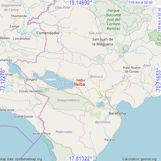
Neiba GPS coordinates[2]
18° 28' 52.932" North, 71° 25' 10.74" West
| Map corner | latitude | longitude |
|---|---|---|
| Upper-left | 19.14692°, | -72.12278° |
| Center: | 18.48137°, | -71.41965° |
| Lower-right: | 17.81322°, | -70.71653° |
| Map W x H: | 148.3×148.3 km | = 92.1×92.1mi |
| max Lat: | 19.89131° ⇑76.3% North |
| Neiba: | 18.48137° |
| min Lat: | ⇓23.7% South 17.80136° |
| min Long | Neiba | max Long |
| -71.85022° | -71.41965° | -68.40431° |
| W 13.3%⇐ | ⇒86.7% E |
Elevation
Elevation of Neiba is 25 m = 82 ft, and this is 141.3 m = 464 ft below average elevation for this country.
| Max E: |
1242 m = 4075 ft | 79.6% |
| Avg. | 166.3 m = 546 ft | |
| Neiba | 25 m = 82 ft | |
Min E: |
5 m = 16 ft | 20.4% |
See also: Dominican Republic elevation on elevation.city.
Geographical zone
Neiba is located in North Torrid zone (between Equator and Tropic of Cancer). Distance of this Northern Tropic circle is 551 km =342.4 mi to North.| Distance of | km | miles | from Neiba |
|---|---|---|---|
| North Pole | 7952.1 | 4941.2 | to North |
| Arctic Circle | 5346.2 | 3322 | to North |
| Tropic Cancer | 551 | 342.4 | to North |
| Equator | 2054.9 | 1276.9 | to South |


Nearby cities:
15 places around Neiba: (largest is in red/bold)
• Cercado Abajo
29.2 km =18.1 mi,  339°
339°
• Cristóbal
24.7 km =15.3 mi,  147°
147°
• Duvergé
15.9 km =9.9 mi,  224°
224°
• El Palmar
19.9 km =12.4 mi,  112°
112°
• Galván
8.4 km =5.2 mi,  74°
74°
• Guayabal
26.8 km =16.7 mi,  298°
298°
• La Uvilla
25.8 km =16 mi,  121°
121°
• Las Salinas
25.4 km =15.8 mi, 154°
• Los Ríos
18.6 km =11.6 mi,  283°
283°
• Mella
13.6 km =8.5 mi,  178°
178°
• Postrer Río
23.8 km =14.8 mi,  286°
286°
• Tamayo
24.8 km =15.4 mi, 112°
• Vallejuelo
21.2 km =13.2 mi,  25°
25°
• Vicente Noble
27.5 km =17.1 mi, 113°
• Villa Jaragua
6.8 km =4.2 mi, 278°
Sources, notices
• [Note1] Compared only with cities in Dominican Republic existing in our database
• [Src1] Map data: © OpenStreetMap contributors (CC-BY-SA)
• [Src2] Other city data from geonames.org with taken over terms of usage.
• [Src3] Geographical zone / Annual Mean Temperature by Robert A. Rohde @ Wikipedia
