Los Ríos geodata
Los Ríos (Baoruco) is a populated place; located in Dominican Republic in America/Santo_Domingo (GMT-4) time zone. With population of 4,440 people, there are 122 cities with bigger population in this country. Compared to other cities in Dominican Republic, 70.6% of cities are located further ↑North; 92.4% of cities are located further →East and 70.1% of cities have higher elevation than Los Ríos. Note1
Administrative division(s):
- Level 1: Baoruco
- Level 2: Los Ríos
- Level 3: Los Ríos
- Level 4: Los Ríos (Zona Urbana)


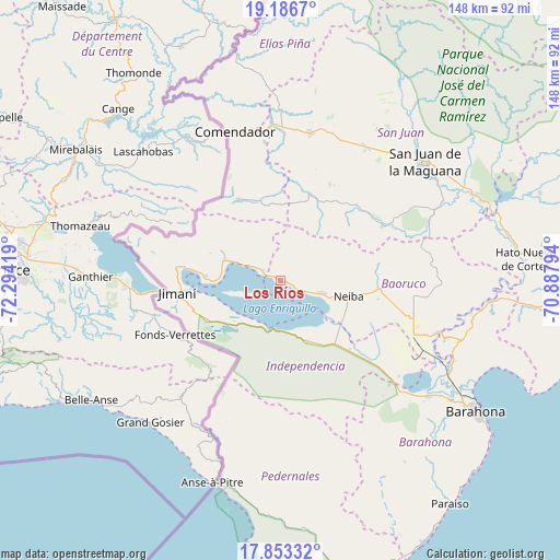
Los Ríos GPS coordinates[2]
18° 31' 16.716" North, 71° 35' 27.816" West
| Map corner | latitude | longitude |
|---|---|---|
| Upper-left | 19.1867°, | -72.29419° |
| Center: | 18.52131°, | -71.59106° |
| Lower-right: | 17.85332°, | -70.88794° |
| Map W x H: | 148.3×148.3 km | = 92.1×92.1mi |
| max Lat: | 19.89131° ⇑70.6% North |
| Los Ríos: | 18.52131° |
| min Lat: | ⇓29.4% South 17.80136° |
| min Long | Los Ríos | max Long |
| -71.85022° | -71.59106° | -68.40431° |
| W 7.6%⇐ | ⇒92.4% E |
Elevation
Elevation of Los Ríos is 34 m = 112 ft, and this is 132.3 m = 434 ft below average elevation for this country.
| Max E: |
1242 m = 4075 ft | 70.1% |
| Avg. | 166.3 m = 546 ft | |
| Los Ríos | 34 m = 112 ft | |
Min E: |
5 m = 16 ft | 29.9% |
See also: Dominican Republic elevation on elevation.city.
Geographical zone
Los Ríos is located in North Torrid zone (between Equator and Tropic of Cancer). Distance of this Northern Tropic circle is 546.5 km =339.6 mi to North.| Distance of | km | miles | from Los Ríos |
|---|---|---|---|
| North Pole | 7947.7 | 4938.5 | to North |
| Arctic Circle | 5341.8 | 3319.2 | to North |
| Tropic Cancer | 546.5 | 339.6 | to North |
| Equator | 2059.4 | 1279.7 | to South |


Nearby cities:
15 places around Los Ríos: (largest is in red/bold)
• Cercado Abajo
24.1 km =15 mi,  18°
18°
• Duvergé
17.4 km =10.8 mi,  156°
156°
• El Llano
33.1 km =20.6 mi,  352°
352°
• El Palmar
38.4 km =23.9 mi,  108°
108°
• Galván
26.3 km =16.3 mi,  94°
94°
• Guayabal
10.1 km =6.3 mi,  327°
327°
• Hondo Valle
24.3 km =15.1 mi, 333°
• Jimaní
27.5 km =17.1 mi,  263°
263°
• Juan Santiago
20.2 km =12.6 mi,  0°
0°
• La Descubierta
15.6 km =9.7 mi,  290°
290°
• Mella
25.8 km =16 mi,  134°
134°
• Neiba
18.6 km =11.6 mi,  103°
103°
• Postrer Río
5.3 km =3.3 mi,  297°
297°
• Vallejuelo
30.8 km =19.1 mi,  61°
61°
• Villa Jaragua
11.8 km =7.3 mi, 106°
Sources, notices
• [Note1] Compared only with cities in Dominican Republic existing in our database
• [Src1] Map data: © OpenStreetMap contributors (CC-BY-SA)
• [Src2] Other city data from geonames.org with taken over terms of usage.
• [Src3] Geographical zone / Annual Mean Temperature by Robert A. Rohde @ Wikipedia
