Matayaya geodata
Matayaya (San Juan) is a populated place; located in Dominican Republic in America/Santo_Domingo (GMT-4) time zone. With population of 1,001 people, there are 205 cities with bigger population in this country. Compared to other cities in Dominican Republic, 51.2% of cities are located further ↓South; 92.9% of cities are located further →East and 87.7% of cities have lower elevation than Matayaya. Note1
Administrative division(s):
- Level 1: San Juan
- Level 2: Las Matas de Farfán
- Level 3: Matayaya (D. M.).
- Level 4: Matayaya (Zona Urbana)


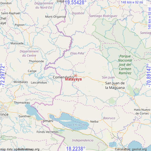
Matayaya GPS coordinates[2]
18° 53' 25.296" North, 71° 35' 40.524" West
| Map corner | latitude | longitude |
|---|---|---|
| Upper-left | 19.55428°, | -72.29772° |
| Center: | 18.89036°, | -71.59459° |
| Lower-right: | 18.2238°, | -70.89147° |
| Map W x H: | 147.9×147.9 km | = 91.9×91.9mi |
| max Lat: | 19.89131° ⇑48.8% North |
| Matayaya: | 18.89036° |
| min Lat: | ⇓51.2% South 17.80136° |
| min Long | Matayaya | max Long |
| -71.85022° | -71.59459° | -68.40431° |
| W 7.1%⇐ | ⇒92.9% E |
Elevation
Elevation of Matayaya is 418 m = 1371 ft, and this is 251.7 m = 826 ft above average elevation for this country.
| Max E: |
1242 m = 4075 ft | 12.3% |
| Matayaya | 418 m 1371 ft | |
| Avg. | 166.3 m = 546 ft | |
Min E: |
5 m = 16 ft | 87.7% |
See also: Dominican Republic elevation on elevation.city.
Geographical zone
Matayaya is located in North Torrid zone (between Equator and Tropic of Cancer). Distance of this Northern Tropic circle is 505.5 km =314.1 mi to North.| Distance of | km | miles | from Matayaya |
|---|---|---|---|
| North Pole | 7906.7 | 4913 | to North |
| Arctic Circle | 5300.8 | 3293.8 | to North |
| Tropic Cancer | 505.5 | 314.1 | to North |
| Equator | 2100.4 | 1305.1 | to South |


Nearby cities:
15 places around Matayaya: (largest is in red/bold)
• Bánica
24.3 km =15.1 mi,  331°
331°
• Cercado Abajo
19.9 km =12.4 mi,  155°
155°
• Comendador
11.5 km =7.1 mi,  262°
262°
• El Llano
9.2 km =5.7 mi,  206°
206°
• Guayabal
32.9 km =20.4 mi,  188°
188°
• Hondo Valle
22.1 km =13.7 mi, 208°
• Juan Santiago
20.8 km =12.9 mi,  178°
178°
• Juan de Herrera
37.5 km =23.3 mi,  92°
92°
• La Descubierta
38.3 km =23.8 mi,  201°
201°
• Las Matas de Farfán
8.4 km =5.2 mi,  103°
103°
• Pedro Corto
19.9 km =12.4 mi, 103°
• Pedro Santana
26.1 km =16.2 mi,  336°
336°
• Postrer Río
38.8 km =24.1 mi, 186°
• San Juan de la Maguana
39.5 km =24.5 mi, 103°
• Vallejuelo
38 km =23.6 mi,  133°
133°
Sources, notices
• [Note1] Compared only with cities in Dominican Republic existing in our database
• [Src1] Map data: © OpenStreetMap contributors (CC-BY-SA)
• [Src2] Other city data from geonames.org with taken over terms of usage.
• [Src3] Geographical zone / Annual Mean Temperature by Robert A. Rohde @ Wikipedia
