Loma de Cabrera geodata
Loma de Cabrera (Dajabón) is a populated place; located in Dominican Republic in America/Santo_Domingo (GMT-4) time zone. With population of 6,679 people, there are 86 cities with bigger population in this country. Compared to other cities in Dominican Republic, 75.4% of cities are located further ↓South; 93.4% of cities are located further →East and 82.5% of cities have lower elevation than Loma de Cabrera. Note1
Administrative division(s):
- Level 1: Dajabón
- Level 2: Loma de Cabrera
- Level 3: Loma De Cabrera
- Level 4: Monte Grande


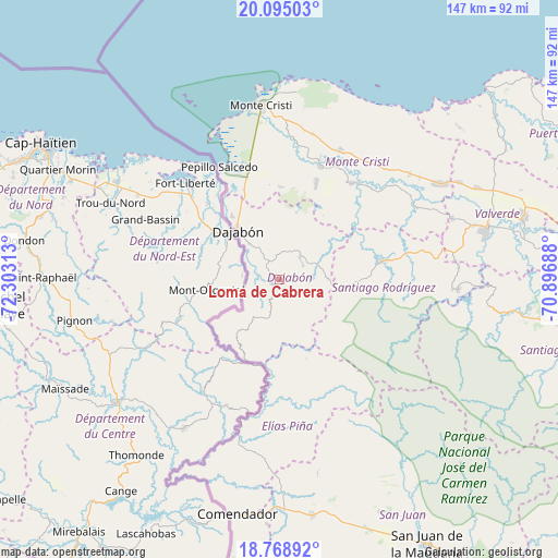
Loma de Cabrera GPS coordinates[2]
19° 25' 59.988" North, 71° 36' 0" West
| Map corner | latitude | longitude |
|---|---|---|
| Upper-left | 20.09503°, | -72.30313° |
| Center: | 19.43333°, | -71.6° |
| Lower-right: | 18.76892°, | -70.89688° |
| Map W x H: | 147.4×147.5 km | = 91.6×91.7mi |
| max Lat: | 19.89131° ⇑24.6% North |
| Loma de Cabrera: | 19.43333° |
| min Lat: | ⇓75.4% South 17.80136° |
| min Long | Loma de Cabrera | max Long |
| -71.85022° | -71.6° | -68.40431° |
| W 6.6%⇐ | ⇒93.4% E |
Elevation
Elevation of Loma de Cabrera is 303 m = 994 ft, and this is 136.7 m = 448 ft above average elevation for this country.
| Max E: |
1242 m = 4075 ft | 17.5% |
| Loma de Cabrera | 303 m 994 ft | |
| Avg. | 166.3 m = 546 ft | |
Min E: |
5 m = 16 ft | 82.5% |
See also: Dominican Republic elevation on elevation.city.
Geographical zone
Loma de Cabrera is located in North Torrid zone (between Equator and Tropic of Cancer). Distance of this Northern Tropic circle is 445.1 km =276.6 mi to North.| Distance of | km | miles | from Loma de Cabrera |
|---|---|---|---|
| North Pole | 7846.3 | 4875.5 | to North |
| Arctic Circle | 5240.4 | 3256.2 | to North |
| Tropic Cancer | 445.1 | 276.6 | to North |
| Equator | 2160.8 | 1342.7 | to South |


Nearby cities:
15 places around Loma de Cabrera: (largest is in red/bold)
• Bánica
40.6 km =25.2 mi,  195°
195°
• Cana Chapetón
40.8 km =25.4 mi,  61°
61°
• Castañuelas
32.9 km =20.4 mi,  18°
18°
• Dajabón
17.1 km =10.6 mi,  318°
318°
• El Pino
13.1 km =8.1 mi,  89°
89°
• Las Matas de Santa Cruz
28.3 km =17.6 mi, 20°
• Partido
7.9 km =4.9 mi,  44°
44°
• Pedro Santana
37.8 km =23.5 mi, 195°
• Pepillo Salcedo
33.2 km =20.6 mi,  332°
332°
• Restauración
16.3 km =10.1 mi,  216°
216°
• Río Limpio
22.2 km =13.8 mi,  160°
160°
• Sabaneta
27.6 km =17.1 mi,  79°
79°
• San Fernando de Monte Cristi
46.4 km =28.8 mi,  354°
354°
• Villa Elisa
44.5 km =27.7 mi,  50°
50°
• Villa Vásquez
37.8 km =23.5 mi,  25°
25°
Sources, notices
• [Note1] Compared only with cities in Dominican Republic existing in our database
• [Src1] Map data: © OpenStreetMap contributors (CC-BY-SA)
• [Src2] Other city data from geonames.org with taken over terms of usage.
• [Src3] Geographical zone / Annual Mean Temperature by Robert A. Rohde @ Wikipedia
