Villa Vásquez geodata
Villa Vásquez (Monte Cristi) is a populated place; located in Dominican Republic in America/Santo_Domingo (GMT-4) time zone. With population of 11,642 people, there are 57 cities with bigger population in this country. Compared to other cities in Dominican Republic, 96.2% of cities are located further ↓South; 87.2% of cities are located further →East and 72% of cities have higher elevation than Villa Vásquez. Note1
Administrative division(s):
- Level 1: Monte Cristi
- Level 2: Villa Vásquez
- Level 3: Villa Vásquez
- Level 4: Villa Vásquez (Zona Urbana)


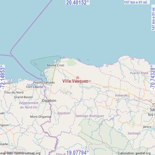
Villa Vásquez GPS coordinates[2]
19° 44' 27.96" North, 71° 26' 47.04" West
| Map corner | latitude | longitude |
|---|---|---|
| Upper-left | 20.40152°, | -72.14953° |
| Center: | 19.7411°, | -71.4464° |
| Lower-right: | 19.07794°, | -70.74328° |
| Map W x H: | 147.2×147.2 km | = 91.5×91.5mi |
| max Lat: | 19.89131° ⇑3.8% North |
| Villa Vásquez: | 19.7411° |
| min Lat: | ⇓96.2% South 17.80136° |
| min Long | Villa Vásquez | max Long |
| -71.85022° | -71.4464° | -68.40431° |
| W 12.8%⇐ | ⇒87.2% E |
Elevation
Elevation of Villa Vásquez is 32 m = 105 ft, and this is 134.3 m = 441 ft below average elevation for this country.
| Max E: |
1242 m = 4075 ft | 72% |
| Avg. | 166.3 m = 546 ft | |
| Villa Vásquez | 32 m = 105 ft | |
Min E: |
5 m = 16 ft | 28% |
See also: Dominican Republic elevation on elevation.city.
Geographical zone
Villa Vásquez is located in North Torrid zone (between Equator and Tropic of Cancer). Distance of this Northern Tropic circle is 410.9 km =255.3 mi to North.| Distance of | km | miles | from Villa Vásquez |
|---|---|---|---|
| North Pole | 7812.1 | 4854.2 | to North |
| Arctic Circle | 5206.2 | 3235 | to North |
| Tropic Cancer | 410.9 | 255.3 | to North |
| Equator | 2195 | 1363.9 | to South |


Nearby cities:
15 places around Villa Vásquez: (largest is in red/bold)
• Cana Chapetón
24.8 km =15.4 mi,  126°
126°
• Castañuelas
6.3 km =3.9 mi,  241°
241°
• Dajabón
34.8 km =21.6 mi,  232°
232°
• El Pino
34.1 km =21.2 mi,  185°
185°
• Estero Hondo
30.1 km =18.7 mi,  71°
71°
• Hatillo Palma
27.8 km =17.3 mi,  108°
108°
• Jaibón
34.4 km =21.4 mi, 114°
• La Caya
34.4 km =21.4 mi,  97°
97°
• Las Matas de Santa Cruz
9.9 km =6.2 mi,  218°
218°
• Loma de Cabrera
37.8 km =23.5 mi,  205°
205°
• Partido
30.5 km =19 mi,  200°
200°
• Pepillo Salcedo
31.6 km =19.6 mi,  261°
261°
• Sabaneta
31.3 km =19.4 mi,  159°
159°
• San Fernando de Monte Cristi
24 km =14.9 mi,  299°
299°
• Villa Elisa
19.5 km =12.1 mi, 108°
Sources, notices
• [Note1] Compared only with cities in Dominican Republic existing in our database
• [Src1] Map data: © OpenStreetMap contributors (CC-BY-SA)
• [Src2] Other city data from geonames.org with taken over terms of usage.
• [Src3] Geographical zone / Annual Mean Temperature by Robert A. Rohde @ Wikipedia
