Jarabacoa geodata
Jarabacoa (La Vega) is a populated place; located in Dominican Republic in America/Santo_Domingo (GMT-4) time zone. With population of 29,983 people, there are 30 cities with bigger population in this country. Compared to other cities in Dominican Republic, 58.8% of cities are located further ↓South; 51.7% of cities are located further →East and 94.3% of cities have lower elevation than Jarabacoa. Note1
Administrative division(s):
- Level 1: La Vega
- Level 2: Jarabacoa
- Level 3: Jarabacoa
- Level 4: Jarabacoa (Zona Urbana)


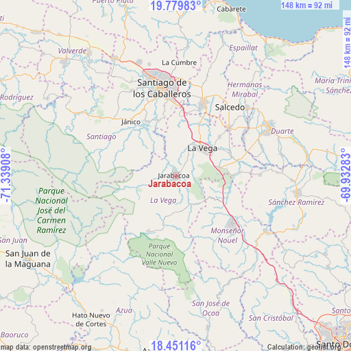
Jarabacoa GPS coordinates[2]
19° 7' 0.588" North, 70° 38' 9.42" West
| Map corner | latitude | longitude |
|---|---|---|
| Upper-left | 19.77983°, | -71.33908° |
| Center: | 19.11683°, | -70.63595° |
| Lower-right: | 18.45116°, | -69.93283° |
| Map W x H: | 147.7×147.7 km | = 91.8×91.8mi |
| max Lat: | 19.89131° ⇑41.2% North |
| Jarabacoa: | 19.11683° |
| min Lat: | ⇓58.8% South 17.80136° |
| min Long | Jarabacoa | max Long |
| -71.85022° | -70.63595° | -68.40431° |
| W 48.3%⇐ | ⇒51.7% E |
Elevation
Elevation of Jarabacoa is 552 m = 1811 ft, and this is 385.7 m = 1265 ft above average elevation for this country.
| Max E: |
1242 m = 4075 ft | 5.7% |
| Jarabacoa | 552 m 1811 ft | |
| Avg. | 166.3 m = 546 ft | |
Min E: |
5 m = 16 ft | 94.3% |
See also: Dominican Republic elevation on elevation.city.
Geographical zone
Jarabacoa is located in North Torrid zone (between Equator and Tropic of Cancer). Distance of this Northern Tropic circle is 480.3 km =298.4 mi to North.| Distance of | km | miles | from Jarabacoa |
|---|---|---|---|
| North Pole | 7881.5 | 4897.3 | to North |
| Arctic Circle | 5275.6 | 3278.1 | to North |
| Tropic Cancer | 480.3 | 298.4 | to North |
| Equator | 2125.6 | 1320.8 | to South |


Nearby cities:
15 places around Jarabacoa: (largest is in red/bold)
• Baitoa
24.2 km =15 mi,  342°
342°
• Bonao
31.1 km =19.3 mi,  130°
130°
• Cayetano Germosén
29.9 km =18.6 mi,  32°
32°
• Cenoví
32 km =19.9 mi,  61°
61°
• Concepción de La Vega
16.2 km =10.1 mi,  43°
43°
• Constanza
25.8 km =16 mi,  206°
206°
• Jima Abajo
27.4 km =17 mi,  86°
86°
• Juncalito Abajo
22.4 km =13.9 mi,  300°
300°
• Moca
32.9 km =20.4 mi,  20°
20°
• Rincón
24.1 km =15 mi, 89°
• Río Verde Arriba
23.3 km =14.5 mi, 18°
• Sabana Iglesia
26.2 km =16.3 mi,  330°
330°
• Sabana del Puerto
23.7 km =14.7 mi,  103°
103°
• Tireo Arriba
20.9 km =13 mi,  195°
195°
• Villa Tapia
30.4 km =18.9 mi,  47°
47°
Sources, notices
• [Note1] Compared only with cities in Dominican Republic existing in our database
• [Src1] Map data: © OpenStreetMap contributors (CC-BY-SA)
• [Src2] Other city data from geonames.org with taken over terms of usage.
• [Src3] Geographical zone / Annual Mean Temperature by Robert A. Rohde @ Wikipedia
