Bonao geodata
Bonao (Monseñor Nouel) is a seat of a first-order administrative division; located in Dominican Republic in America/Santo_Domingo (GMT-4) time zone. With population of 73,269 people, there are 14 cities with bigger population in this country. Compared to other cities in Dominican Republic, 52.6% of cities are located further ↓South; 58.3% of cities are located further ←West and 70.1% of cities have lower elevation than Bonao. Note1
Administrative division(s):
- Level 1: Monseñor Nouel
- Level 2: Bonao
- Level 3: Bonao
- Level 4: Bonao (Zona Urbana)


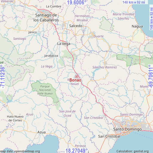
Bonao GPS coordinates[2]
18° 56' 12.732" North, 70° 24' 33.228" West
| Map corner | latitude | longitude |
|---|---|---|
| Upper-left | 19.6006°, | -71.11236° |
| Center: | 18.93687°, | -70.40923° |
| Lower-right: | 18.27049°, | -69.70611° |
| Map W x H: | 147.9×147.9 km | = 91.9×91.9mi |
| max Lat: | 19.89131° ⇑47.4% North |
| Bonao: | 18.93687° |
| min Lat: | ⇓52.6% South 17.80136° |
| min Long | Bonao | max Long |
| -71.85022° | -70.40923° | -68.40431° |
| W 58.3%⇐ | ⇒41.7% E |
Elevation
Elevation of Bonao is 177 m = 581 ft, and this is 10.7 m = 35 ft above average elevation for this country.
| Max E: |
1242 m = 4075 ft | 29.9% |
| Bonao | 177 m 581 ft | |
| Avg. | 166.3 m = 546 ft | |
Min E: |
5 m = 16 ft | 70.1% |
See also: Bonao elevation on elevation.city.
Geographical zone
Bonao is located in North Torrid zone (between Equator and Tropic of Cancer). Distance of this Northern Tropic circle is 500.3 km =310.9 mi to North.| Distance of | km | miles | from Bonao |
|---|---|---|---|
| North Pole | 7901.5 | 4909.8 | to North |
| Arctic Circle | 5295.6 | 3290.5 | to North |
| Tropic Cancer | 500.3 | 310.9 | to North |
| Equator | 2105.6 | 1308.4 | to South |


Nearby cities:
15 places around Bonao: (largest is in red/bold)
• Cenoví
35.6 km =22.1 mi,  6°
6°
• Concepción de La Vega
34.1 km =21.2 mi,  338°
338°
• Constanza
35.4 km =22 mi,  265°
265°
• Cotuí
30.2 km =18.8 mi,  64°
64°
• Fantino
23.5 km =14.6 mi,  29°
29°
• Jarabacoa
31.1 km =19.3 mi,  310°
310°
• Jima Abajo
22.1 km =13.7 mi, 9°
• Juan Adrián
20.7 km =12.9 mi,  158°
158°
• Las Guáranas
35.5 km =22.1 mi,  36°
36°
• Piedra Blanca
14.2 km =8.8 mi,  136°
136°
• Rincón
20.3 km =12.6 mi,  0°
0°
• Sabana del Puerto
14.5 km =9 mi,  356°
356°
• Tireo Arriba
29.4 km =18.3 mi, 269°
• Villa Altagracia
38.6 km =24 mi, 139°
• Villa La Mata
17.4 km =10.8 mi, 59°
Sources, notices
• [Note1] Compared only with cities in Dominican Republic existing in our database
• [Src1] Map data: © OpenStreetMap contributors (CC-BY-SA)
• [Src2] Other city data from geonames.org with taken over terms of usage.
• [Src3] Geographical zone / Annual Mean Temperature by Robert A. Rohde @ Wikipedia
