Constanza geodata
Constanza (La Vega) is a populated place; located in Dominican Republic in America/Santo_Domingo (GMT-4) time zone. With population of 29,481 people, there are 31 cities with bigger population in this country. Compared to other cities in Dominican Republic, 51.7% of cities are located further ↓South; 55.9% of cities are located further →East and 99.5% of cities have lower elevation than Constanza. Note1
Administrative division(s):
- Level 1: La Vega
- Level 2: Constanza
- Level 3: Constanza
- Level 4: Constanza (Zona Urbana)


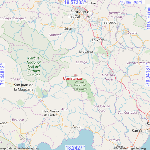
Constanza GPS coordinates[2]
18° 54' 33.084" North, 70° 44' 41.964" West
| Map corner | latitude | longitude |
|---|---|---|
| Upper-left | 19.57303°, | -71.44812° |
| Center: | 18.90919°, | -70.74499° |
| Lower-right: | 18.2427°, | -70.04187° |
| Map W x H: | 147.9×147.9 km | = 91.9×91.9mi |
| max Lat: | 19.89131° ⇑48.3% North |
| Constanza: | 18.90919° |
| min Lat: | ⇓51.7% South 17.80136° |
| min Long | Constanza | max Long |
| -71.85022° | -70.74499° | -68.40431° |
| W 44.1%⇐ | ⇒55.9% E |
Elevation
Elevation of Constanza is 1177 m = 3862 ft, and this is 1010.7 m = 3316 ft above average elevation for this country.
| Max E: |
1242 m = 4075 ft | 0.5% |
| Constanza | 1177 m 3862 ft | |
| Avg. | 166.3 m = 546 ft | |
Min E: |
5 m = 16 ft | 99.5% |
See also: Dominican Republic elevation on elevation.city.
Geographical zone
Constanza is located in North Torrid zone (between Equator and Tropic of Cancer). Distance of this Northern Tropic circle is 503.4 km =312.8 mi to North.| Distance of | km | miles | from Constanza |
|---|---|---|---|
| North Pole | 7904.6 | 4911.7 | to North |
| Arctic Circle | 5298.7 | 3292.5 | to North |
| Tropic Cancer | 503.4 | 312.8 | to North |
| Equator | 2102.5 | 1306.4 | to South |


Nearby cities:
15 places around Constanza: (largest is in red/bold)
• Bohechío
29.7 km =18.5 mi,  239°
239°
• Bonao
35.4 km =22 mi,  85°
85°
• Concepción de La Vega
41.5 km =25.8 mi,  33°
33°
• El Guayabal
20.2 km =12.6 mi,  208°
208°
• Jarabacoa
25.8 km =16 mi, 26°
• Juncalito Abajo
35.4 km =22 mi,  347°
347°
• Padre Las Casas
28.4 km =17.6 mi,  226°
226°
• Peralta
36.5 km =22.7 mi,  184°
184°
• Rincón
42.6 km =26.5 mi,  56°
56°
• Sabana Yegua
35.7 km =22.2 mi, 233°
• Sabana del Puerto
38.7 km =24 mi, 63°
• Tireo Arriba
6.6 km =4.1 mi, 63°
• Tábara Arriba
40.3 km =25 mi,  200°
200°
• Villarpando
41.7 km =25.9 mi, 228°
• Yayas de Viajama
38.7 km =24 mi, 209°
Sources, notices
• [Note1] Compared only with cities in Dominican Republic existing in our database
• [Src1] Map data: © OpenStreetMap contributors (CC-BY-SA)
• [Src2] Other city data from geonames.org with taken over terms of usage.
• [Src3] Geographical zone / Annual Mean Temperature by Robert A. Rohde @ Wikipedia
