Jamao al Norte geodata
Jamao al Norte (Espaillat) is a populated place; located in Dominican Republic in America/Santo_Domingo (GMT-4) time zone. With population of 2,216 people, there are 164 cities with bigger population in this country. Compared to other cities in Dominican Republic, 88.2% of cities are located further ↓South; 55.9% of cities are located further ←West and 57.8% of cities have higher elevation than Jamao al Norte. Note1
Administrative division(s):
- Level 1: Espaillat
- Level 2: Jamao Al Norte
- Level 3: Jamao Al Norte
- Level 4: Jamao Al Norte (Zona Urbana)


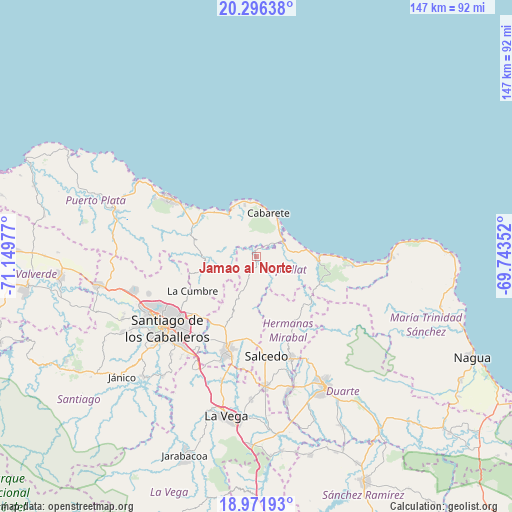
Jamao al Norte GPS coordinates[2]
19° 38' 7.872" North, 70° 26' 47.904" West
| Map corner | latitude | longitude |
|---|---|---|
| Upper-left | 20.29638°, | -71.14977° |
| Center: | 19.63552°, | -70.44664° |
| Lower-right: | 18.97193°, | -69.74352° |
| Map W x H: | 147.3×147.3 km | = 91.5×91.5mi |
| max Lat: | 19.89131° ⇑11.8% North |
| Jamao al Norte: | 19.63552° |
| min Lat: | ⇓88.2% South 17.80136° |
| min Long | Jamao al Norte | max Long |
| -71.85022° | -70.44664° | -68.40431° |
| W 55.9%⇐ | ⇒44.1% E |
Elevation
Elevation of Jamao al Norte is 51 m = 167 ft, and this is 115.3 m = 378 ft below average elevation for this country.
| Max E: |
1242 m = 4075 ft | 57.8% |
| Avg. | 166.3 m = 546 ft | |
| Jamao al Norte | 51 m = 167 ft | |
Min E: |
5 m = 16 ft | 42.2% |
See also: Dominican Republic elevation on elevation.city.
Geographical zone
Jamao al Norte is located in North Torrid zone (between Equator and Tropic of Cancer). Distance of this Northern Tropic circle is 422.7 km =262.7 mi to North.| Distance of | km | miles | from Jamao al Norte |
|---|---|---|---|
| North Pole | 7823.8 | 4861.5 | to North |
| Arctic Circle | 5217.9 | 3242.3 | to North |
| Tropic Cancer | 422.7 | 262.7 | to North |
| Equator | 2183.3 | 1356.6 | to South |


Nearby cities:
15 places around Jamao al Norte: (largest is in red/bold)
• Cabarete
13.3 km =8.3 mi,  17°
17°
• Gaspar Hernández
17.7 km =11 mi,  92°
92°
• Joba Arriba
20.3 km =12.6 mi,  112°
112°
• José Contreras
18.5 km =11.5 mi,  181°
181°
• Juan López Abajo
23.2 km =14.4 mi,  193°
193°
• Licey al Medio
27.6 km =17.1 mi,  215°
215°
• Moca
28.2 km =17.5 mi,  197°
197°
• Monte Llano
19.4 km =12.1 mi,  304°
304°
• Pedro García
22.1 km =13.7 mi,  257°
257°
• Salcedo
28.8 km =17.9 mi,  173°
173°
• Salsipuedes
26.5 km =16.5 mi,  164°
164°
• San Víctor Arriba
19.9 km =12.4 mi,  207°
207°
• Sosúa
15.1 km =9.4 mi,  329°
329°
• Tamboril
24 km =14.9 mi,  225°
225°
• Veragua Arriba
13.2 km =8.2 mi,  116°
116°
Sources, notices
• [Note1] Compared only with cities in Dominican Republic existing in our database
• [Src1] Map data: © OpenStreetMap contributors (CC-BY-SA)
• [Src2] Other city data from geonames.org with taken over terms of usage.
• [Src3] Geographical zone / Annual Mean Temperature by Robert A. Rohde @ Wikipedia
