Pedro García geodata
Pedro García (Santiago) is a populated place; located in Dominican Republic in America/Santo_Domingo (GMT-4) time zone. With population of 1,457 people, there are 194 cities with bigger population in this country. Compared to other cities in Dominican Republic, 86.3% of cities are located further ↓South; 52.6% of cities are located further →East and 89.1% of cities have lower elevation than Pedro García. Note1
Administrative division(s):
- Level 1: Santiago
- Level 2: Santiago de los Caballeros
- Level 3: Pedro García (D. M.).
- Level 4: Pedro García (Zona Urbana)


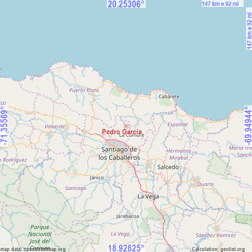
Pedro García GPS coordinates[2]
19° 35' 31.272" North, 70° 39' 9.216" West
| Map corner | latitude | longitude |
|---|---|---|
| Upper-left | 20.25306°, | -71.35569° |
| Center: | 19.59202°, | -70.65256° |
| Lower-right: | 18.92825°, | -69.94944° |
| Map W x H: | 147.3×147.3 km | = 91.5×91.5mi |
| max Lat: | 19.89131° ⇑13.7% North |
| Pedro García: | 19.59202° |
| min Lat: | ⇓86.3% South 17.80136° |
| min Long | Pedro García | max Long |
| -71.85022° | -70.65256° | -68.40431° |
| W 47.4%⇐ | ⇒52.6% E |
Elevation
Elevation of Pedro García is 454 m = 1490 ft, and this is 287.7 m = 944 ft above average elevation for this country.
| Max E: |
1242 m = 4075 ft | 10.9% |
| Pedro García | 454 m 1490 ft | |
| Avg. | 166.3 m = 546 ft | |
Min E: |
5 m = 16 ft | 89.1% |
See also: Dominican Republic elevation on elevation.city.
Geographical zone
Pedro García is located in North Torrid zone (between Equator and Tropic of Cancer). Distance of this Northern Tropic circle is 427.5 km =265.6 mi to North.| Distance of | km | miles | from Pedro García |
|---|---|---|---|
| North Pole | 7828.6 | 4864.5 | to North |
| Arctic Circle | 5222.7 | 3245.2 | to North |
| Tropic Cancer | 427.5 | 265.6 | to North |
| Equator | 2178.4 | 1353.6 | to South |


Nearby cities:
15 places around Pedro García: (largest is in red/bold)
• Altamira
22.2 km =13.8 mi,  295°
295°
• Jamao al Norte
22.1 km =13.7 mi,  77°
77°
• Juan López Abajo
23.8 km =14.8 mi,  137°
137°
• La Canela
21.6 km =13.4 mi,  232°
232°
• Licey al Medio
18.5 km =11.5 mi,  162°
162°
• Monte Llano
16.8 km =10.4 mi,  19°
19°
• Palmar Arriba
10.7 km =6.6 mi,  236°
236°
• Puerto Plata
22.7 km =14.1 mi,  350°
350°
• Río Grande
14.6 km =9.1 mi, 304°
• San Víctor Arriba
17.7 km =11 mi, 136°
• Santiago de los Caballeros
16.3 km =10.1 mi,  196°
196°
• Sosúa
22.6 km =14 mi,  37°
37°
• Tamboril
12.6 km =7.8 mi, 159°
• Villa Bisonó
23.6 km =14.7 mi,  262°
262°
• Villa González
15.4 km =9.6 mi,  248°
248°
Sources, notices
• [Note1] Compared only with cities in Dominican Republic existing in our database
• [Src1] Map data: © OpenStreetMap contributors (CC-BY-SA)
• [Src2] Other city data from geonames.org with taken over terms of usage.
• [Src3] Geographical zone / Annual Mean Temperature by Robert A. Rohde @ Wikipedia
