Monte Llano geodata
Monte Llano (Puerto Plata) is a populated place; located in Dominican Republic in America/Santo_Domingo (GMT-4) time zone. With population of 19,029 people, there are 39 cities with bigger population in this country. Compared to other cities in Dominican Republic, 95.7% of cities are located further ↓South; 50.2% of cities are located further ←West and 92.4% of cities have higher elevation than Monte Llano. Note1
Administrative division(s):
- Level 1: Puerto Plata
- Level 2: Villa Montellano
- Level 3: Villa Montellano
- Level 4: Villa Montellano (Zona Urbana)


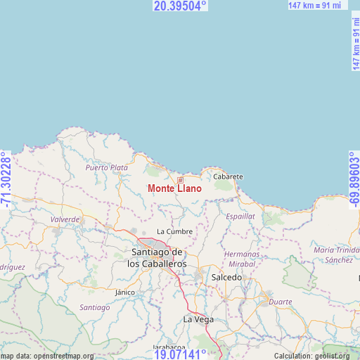
Monte Llano GPS coordinates[2]
19° 44' 4.56" North, 70° 35' 56.94" West
| Map corner | latitude | longitude |
|---|---|---|
| Upper-left | 20.39504°, | -71.30228° |
| Center: | 19.7346°, | -70.59915° |
| Lower-right: | 19.07141°, | -69.89603° |
| Map W x H: | 147.2×147.2 km | = 91.5×91.5mi |
| max Lat: | 19.89131° ⇑4.3% North |
| Monte Llano: | 19.7346° |
| min Lat: | ⇓95.7% South 17.80136° |
| min Long | Monte Llano | max Long |
| -71.85022° | -70.59915° | -68.40431° |
| W 50.2%⇐ | ⇒49.8% E |
Elevation
Elevation of Monte Llano is 12 m = 39 ft, and this is 154.3 m = 506 ft below average elevation for this country.
| Max E: |
1242 m = 4075 ft | 92.4% |
| Avg. | 166.3 m = 546 ft | |
| Monte Llano | 12 m = 39 ft | |
Min E: |
5 m = 16 ft | 7.6% |
See also: Dominican Republic elevation on elevation.city.
Geographical zone
Monte Llano is located in North Torrid zone (between Equator and Tropic of Cancer). Distance of this Northern Tropic circle is 411.6 km =255.8 mi to North.| Distance of | km | miles | from Monte Llano |
|---|---|---|---|
| North Pole | 7812.8 | 4854.6 | to North |
| Arctic Circle | 5206.9 | 3235.4 | to North |
| Tropic Cancer | 411.6 | 255.8 | to North |
| Equator | 2194.3 | 1363.5 | to South |


Nearby cities:
15 places around Monte Llano: (largest is in red/bold)
• Altamira
26.4 km =16.4 mi,  256°
256°
• Cabarete
20 km =12.4 mi,  85°
85°
• Imbert
24.2 km =15 mi,  275°
275°
• Jamao al Norte
19.4 km =12.1 mi,  124°
124°
• José Contreras
33.2 km =20.6 mi,  152°
152°
• Palmar Arriba
26.1 km =16.2 mi,  213°
213°
• Pedro García
16.8 km =10.4 mi,  199°
199°
• Puerto Plata
11.4 km =7.1 mi,  305°
305°
• Río Grande
19.1 km =11.9 mi,  246°
246°
• San Víctor Arriba
29.4 km =18.3 mi,  166°
166°
• Santiago de los Caballeros
33.1 km =20.6 mi, 198°
• Sosúa
8.5 km =5.3 mi,  76°
76°
• Tamboril
27.7 km =17.2 mi,  182°
182°
• Veragua Arriba
32.5 km =20.2 mi, 121°
• Villa González
29.3 km =18.2 mi,  222°
222°
Sources, notices
• [Note1] Compared only with cities in Dominican Republic existing in our database
• [Src1] Map data: © OpenStreetMap contributors (CC-BY-SA)
• [Src2] Other city data from geonames.org with taken over terms of usage.
• [Src3] Geographical zone / Annual Mean Temperature by Robert A. Rohde @ Wikipedia
