Freha geodata
Freha (Tizi Ouzou) is a populated place; located in Algeria in Africa/Algiers (GMT+1) time zone. With population of 31,068 people, there are 168 cities with bigger population in this country. Compared to other cities in Algeria, 92.2% of cities are located further ↓South; 63.2% of cities are located further ←West and 61.2% of cities have higher elevation than Freha. Note1


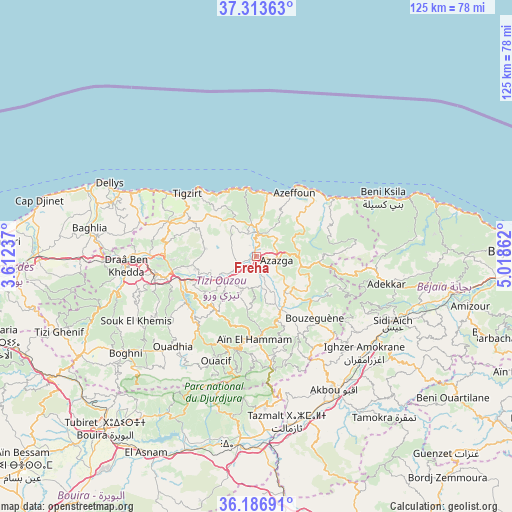
Freha GPS coordinates[2]
36° 45' 8.424" North, 4° 18' 55.8" East
| Map corner | latitude | longitude |
|---|---|---|
| Upper-left | 37.31363°, | 3.61237° |
| Center: | 36.75234°, | 4.3155° |
| Lower-right: | 36.18691°, | 5.01862° |
| Map W x H: | 125.3×125.3 km | = 77.9×77.9mi |
| max Lat: | 36.92917° ⇑7.8% North |
| Freha: | 36.75234° |
| min Lat: | ⇓92.2% South 22.785° |
| min Long | Freha | max Long |
| -8.14743° | 4.3155° | 8.46667° |
| W 63.2%⇐ | ⇒36.8% E |
Elevation
Elevation of Freha is 170 m = 558 ft, and this is 268.5 m = 881 ft below average elevation for this country.
| Max E: |
1392 m = 4567 ft | 61.2% |
| Avg. | 438.5 m = 1439 ft | |
| Freha | 170 m = 558 ft | |
Min E: |
5 m = 16 ft | 38.8% |
See also: Algeria elevation on elevation.city.
Geographical zone
Freha is located in North temperate zone (between Tropic of Cancer and the Arctic Circle). Distance of this Northern Tropic circle is 1480.6 km =920 mi to South.| Distance of | km | miles | from Freha |
|---|---|---|---|
| North Pole | 5920.6 | 3678.9 | to North |
| Arctic Circle | 3314.7 | 2059.7 | to North |
| Tropic Cancer | 1480.6 | 920 | to South |
| Equator | 4086.5 | 2539.2 | to South |


Nearby cities:
15 places around Freha: (largest is in red/bold)
• Ait Yahia
18.2 km =11.3 mi,  174°
174°
• Arhribs
4.6 km =2.9 mi,  355°
355°
• Azazga
5.1 km =3.2 mi,  99°
99°
• Beni Douala
25.5 km =15.8 mi,  234°
234°
• Boudjima
15.6 km =9.7 mi,  290°
290°
• Chemini
31.8 km =19.8 mi,  122°
122°
• Draa Ben Khedda
31.5 km =19.6 mi,  266°
266°
• L’Arbaa Naït Irathen
17 km =10.6 mi,  217°
217°
• Makouda
22.8 km =14.2 mi,  279°
279°
• Mekla
9.1 km =5.7 mi,  210°
210°
• Timizart
6.9 km =4.3 mi,  320°
320°
• Tirmitine
31.7 km =19.7 mi,  249°
249°
• Tizi Ouzou
24.4 km =15.2 mi,  259°
259°
• Tizi Rached
14.2 km =8.8 mi, 230°
• ’Aïn el Hammam
20.9 km =13 mi,  182°
182°
Sources, notices
• [Note1] Compared only with cities in Algeria existing in our database
• [Src1] Map data: © OpenStreetMap contributors (CC-BY-SA)
• [Src2] Other city data from geonames.org with taken over terms of usage.
• [Src3] Geographical zone / Annual Mean Temperature by Robert A. Rohde @ Wikipedia
