Arhribs geodata
Arhribs (Tizi Ouzou) is a populated place; located in Algeria in Africa/Algiers (GMT+1) time zone. With population of 23,958 people, there are 205 cities with bigger population in this country. Compared to other cities in Algeria, 95.3% of cities are located further ↓South; 62.8% of cities are located further ←West and 55% of cities have lower elevation than Arhribs. Note1


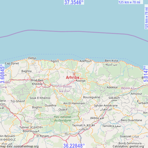
Arhribs GPS coordinates[2]
36° 47' 36.996" North, 4° 18' 41.688" East
| Map corner | latitude | longitude |
|---|---|---|
| Upper-left | 37.3546°, | 3.60845° |
| Center: | 36.79361°, | 4.31158° |
| Lower-right: | 36.22848°, | 5.0147° |
| Map W x H: | 125.2×125.2 km | = 77.8×77.8mi |
| max Lat: | 36.92917° ⇑4.7% North |
| Arhribs: | 36.79361° |
| min Lat: | ⇓95.3% South 22.785° |
| min Long | Arhribs | max Long |
| -8.14743° | 4.31158° | 8.46667° |
| W 62.8%⇐ | ⇒37.2% E |
Elevation
Elevation of Arhribs is 375 m = 1230 ft, and this is 63.5 m = 208 ft below average elevation for this country.
| Max E: |
1392 m = 4567 ft | 45% |
| Avg. | 438.5 m = 1439 ft | |
| Arhribs | 375 m = 1230 ft | |
Min E: |
5 m = 16 ft | 55% |
See also: Algeria elevation on elevation.city.
Geographical zone
Arhribs is located in North temperate zone (between Tropic of Cancer and the Arctic Circle). Distance of this Northern Tropic circle is 1485.1 km =922.8 mi to South.| Distance of | km | miles | from Arhribs |
|---|---|---|---|
| North Pole | 5916 | 3676 | to North |
| Arctic Circle | 3310.1 | 2056.8 | to North |
| Tropic Cancer | 1485.1 | 922.8 | to South |
| Equator | 4091.1 | 2542.1 | to South |


Nearby cities:
15 places around Arhribs: (largest is in red/bold)
• Ait Yahia
22.8 km =14.2 mi,  174°
174°
• Azazga
7.7 km =4.8 mi,  135°
135°
• Beni Douala
28.1 km =17.5 mi,  226°
226°
• Boudjima
14.3 km =8.9 mi,  273°
273°
• Chemini
34.7 km =21.6 mi,  128°
128°
• Draa Ben Khedda
31.8 km =19.8 mi,  258°
258°
• Freha
4.6 km =2.9 mi,  175°
175°
• L’Arbaa Naït Irathen
20.7 km =12.9 mi,  209°
209°
• Makouda
22.2 km =13.8 mi, 267°
• Mekla
13.1 km =8.1 mi,  198°
198°
• Timizart
4.1 km =2.5 mi,  280°
280°
• Tirmitine
33.3 km =20.7 mi,  242°
242°
• Tizi Ouzou
25.4 km =15.8 mi,  248°
248°
• Tizi Rached
17.3 km =10.7 mi,  218°
218°
• ’Aïn el Hammam
25.5 km =15.8 mi, 181°
Sources, notices
• [Note1] Compared only with cities in Algeria existing in our database
• [Src1] Map data: © OpenStreetMap contributors (CC-BY-SA)
• [Src2] Other city data from geonames.org with taken over terms of usage.
• [Src3] Geographical zone / Annual Mean Temperature by Robert A. Rohde @ Wikipedia
