’Aïn el Hammam geodata
’Aïn el Hammam (Tizi Ouzou) is a populated place; located in Algeria in Africa/Algiers (GMT+1) time zone. With population of 28,029 people, there are 183 cities with bigger population in this country. Compared to other cities in Algeria, 74% of cities are located further ↓South; 62.4% of cities are located further ←West and 77.1% of cities have lower elevation than ’Aïn el Hammam. Note1


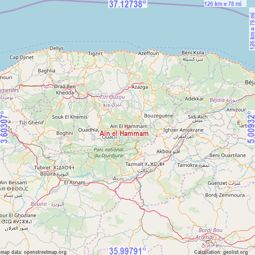
’Aïn el Hammam GPS coordinates[2]
36° 33' 52.956" North, 4° 18' 22.284" East
| Map corner | latitude | longitude |
|---|---|---|
| Upper-left | 37.12738°, | 3.60307° |
| Center: | 36.56471°, | 4.30619° |
| Lower-right: | 35.99791°, | 5.00932° |
| Map W x H: | 125.6×125.6 km | = 78×78mi |
| max Lat: | 36.92917° ⇑26% North |
| ’Aïn el Hammam: | 36.56471° |
| min Lat: | ⇓74% South 22.785° |
| min Long | ’Aïn el Hamm | max Long |
| -8.14743° | 4.30619° | 8.46667° |
| W 62.4%⇐ | ⇒37.6% E |
Elevation
Elevation of ’Aïn el Hammam is 841 m = 2759 ft, and this is 402.5 m = 1321 ft above average elevation for this country.
| Max E: |
1392 m = 4567 ft | 22.9% |
| ’Aïn el Hammam | 841 m 2759 ft | |
| Avg. | 438.5 m = 1439 ft | |
Min E: |
5 m = 16 ft | 77.1% |
See also: Algeria elevation on elevation.city.
Geographical zone
’Aïn el Hammam is located in North temperate zone (between Tropic of Cancer and the Arctic Circle). Distance of this Northern Tropic circle is 1459.7 km =907 mi to South.| Distance of | km | miles | from ’Aïn el Hammam |
|---|---|---|---|
| North Pole | 5941.4 | 3691.8 | to North |
| Arctic Circle | 3335.6 | 2072.6 | to North |
| Tropic Cancer | 1459.7 | 907 | to South |
| Equator | 4065.6 | 2526.2 | to South |


Nearby cities:
15 places around ’Aïn el Hammam: (largest is in red/bold)
• Ait Yahia
3.7 km =2.3 mi,  43°
43°
• Akbou
23.7 km =14.7 mi,  120°
120°
• Arhribs
25.5 km =15.8 mi,  1°
1°
• Azazga
20.9 km =13 mi,  16°
16°
• Beni Douala
20.9 km =13 mi,  286°
286°
• Chemini
28 km =17.4 mi,  81°
81°
• Chorfa
22.3 km =13.9 mi,  175°
175°
• Freha
20.9 km =13 mi, 2°
• Ighram
21.1 km =13.1 mi, 122°
• L’Arbaa Naït Irathen
12.1 km =7.5 mi,  307°
307°
• Mekla
13.6 km =8.5 mi,  343°
343°
• Timizart
26.4 km =16.4 mi,  352°
352°
• Tizi Ouzou
28.4 km =17.6 mi, 305°
• Tizi Rached
15.7 km =9.8 mi,  319°
319°
• Tizi-n-Tleta
22.3 km =13.9 mi,  264°
264°
Sources, notices
• [Note1] Compared only with cities in Algeria existing in our database
• [Src1] Map data: © OpenStreetMap contributors (CC-BY-SA)
• [Src2] Other city data from geonames.org with taken over terms of usage.
• [Src3] Geographical zone / Annual Mean Temperature by Robert A. Rohde @ Wikipedia
