Kohila geodata
Kohila (Raplamaa) is a seat of a second-order administrative division; located in Estonia in Europe/Tallinn (GMT+3) time zone. With population of 3,355 people, there are 33 cities with bigger population in this country. Compared to other cities in Estonia, 64.2% of cities are located further ↓South; 73.7% of cities are located further →East and 55.8% of cities have lower elevation than Kohila. Note1


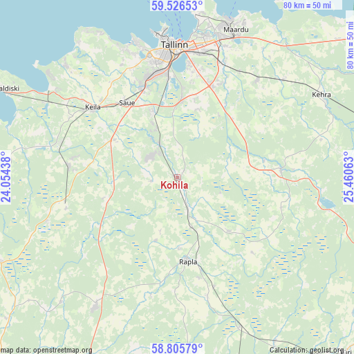
Kohila GPS coordinates[2]
59° 10' 5.016" North, 24° 45' 27" East
| Map corner | latitude | longitude |
|---|---|---|
| Upper-left | 59.52653°, | 24.05438° |
| Center: | 59.16806°, | 24.7575° |
| Lower-right: | 58.80579°, | 25.46063° |
| Map W x H: | 80.1×80.1 km | = 49.8×49.8mi |
| max Lat: | 59.57639° ⇑35.8% North |
| Kohila: | 59.16806° |
| min Lat: | ⇓64.2% South 57.72778° |
| min Long | Kohila | max Long |
| 22.24646° | 24.7575° | 28.19028° |
| W 26.3%⇐ | ⇒73.7% E |
Elevation
Elevation of Kohila is 58 m = 190 ft, and this is 4.8 m = 16 ft above average elevation for this country.
| Max E: |
141 m = 463 ft | 44.2% |
| Kohila | 58 m 190 ft | |
| Avg. | 53.2 m = 175 ft | |
Min E: |
6 m = 20 ft | 55.8% |
See also: Estonia elevation on elevation.city.
Geographical zone
Kohila is located in North temperate zone (between Tropic of Cancer and the Arctic Circle). Distance of this North polar circle is 822.3 km =511 mi to North.| Distance of | km | miles | from Kohila |
|---|---|---|---|
| North Pole | 3428.2 | 2130.2 | to North |
| Arctic Circle | 822.3 | 511 | to North |
| Tropic Cancer | 3973 | 2468.7 | to South |
| Equator | 6578.9 | 4087.9 | to South |


Nearby cities:
15 places around Kohila: (largest is in red/bold)
• Alu
16.2 km =10.1 mi,  179°
179°
• Harku
22.4 km =13.9 mi,  259°
259°
• Juuru
15.9 km =9.9 mi,  136°
136°
• Jüri
22.1 km =13.7 mi,  20°
20°
• Kaerepere
23 km =14.3 mi,  167°
167°
• Kiili
16.2 km =10.1 mi, 16°
• Kiisa
8.6 km =5.3 mi,  332°
332°
• Kose-Uuemõisa
20.1 km =12.5 mi,  79°
79°
• Laagri
21.9 km =13.6 mi,  338°
338°
• Luige
17.7 km =11 mi,  3°
3°
• Rapla
18 km =11.2 mi, 173°
• Saku
16 km =9.9 mi, 340°
• Saue
20.9 km =13 mi, 325°
• Vaida
18.1 km =11.2 mi,  43°
43°
• Ääsmäe
15.9 km =9.9 mi,  300°
300°
Sources, notices
• [Note1] Compared only with cities in Estonia existing in our database
• [Src1] Map data: © OpenStreetMap contributors (CC-BY-SA)
• [Src2] Other city data from geonames.org with taken over terms of usage.
• [Src3] Geographical zone / Annual Mean Temperature by Robert A. Rohde @ Wikipedia
