Rapla geodata
Rapla (Raplamaa) is a seat of a first-order administrative division; located in Estonia in Europe/Tallinn (GMT+3) time zone. With population of 5,684 people, there are 22 cities with bigger population in this country. Compared to other cities in Estonia, 57.9% of cities are located further ↓South; 71.6% of cities are located further →East and 71.1% of cities have lower elevation than Rapla. Note1


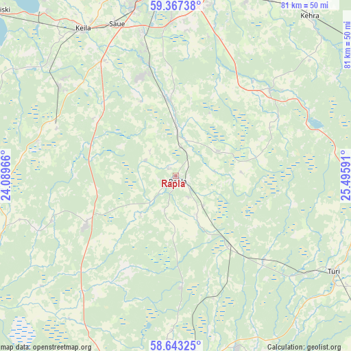
Rapla GPS coordinates[2]
59° 0' 25.992" North, 24° 47' 34.008" East
| Map corner | latitude | longitude |
|---|---|---|
| Upper-left | 59.36738°, | 24.08966° |
| Center: | 59.00722°, | 24.79278° |
| Lower-right: | 58.64325°, | 25.49591° |
| Map W x H: | 80.5×80.5 km | = 50×50mi |
| max Lat: | 59.57639° ⇑42.1% North |
| Rapla: | 59.00722° |
| min Lat: | ⇓57.9% South 57.72778° |
| min Long | Rapla | max Long |
| 22.24646° | 24.79278° | 28.19028° |
| W 28.4%⇐ | ⇒71.6% E |
Elevation
Elevation of Rapla is 67 m = 220 ft, and this is 13.8 m = 45 ft above average elevation for this country.
| Max E: |
141 m = 463 ft | 28.9% |
| Rapla | 67 m 220 ft | |
| Avg. | 53.2 m = 175 ft | |
Min E: |
6 m = 20 ft | 71.1% |
See also: Estonia elevation on elevation.city.
Geographical zone
Rapla is located in North temperate zone (between Tropic of Cancer and the Arctic Circle). Distance of this North polar circle is 840.2 km =522.1 mi to North.| Distance of | km | miles | from Rapla |
|---|---|---|---|
| North Pole | 3446.1 | 2141.3 | to North |
| Arctic Circle | 840.2 | 522.1 | to North |
| Tropic Cancer | 3955.1 | 2457.6 | to South |
| Equator | 6561 | 4076.8 | to South |


Nearby cities:
15 places around Rapla: (largest is in red/bold)
• Alu
2.5 km =1.6 mi,  312°
312°
• Harku
27.8 km =17.3 mi,  300°
300°
• Juuru
11 km =6.8 mi,  54°
54°
• Järvakandi
25.5 km =15.8 mi,  175°
175°
• Kaerepere
5.5 km =3.4 mi,  147°
147°
• Kehtna
9.9 km =6.2 mi, 150°
• Kiisa
26.2 km =16.3 mi,  346°
346°
• Kohila
18 km =11.2 mi, 353°
• Kose
28.9 km =18 mi, 48°
• Kose-Uuemõisa
27.9 km =17.3 mi,  39°
39°
• Märjamaa
23.7 km =14.7 mi,  241°
241°
• Orgita
22.6 km =14 mi,  247°
247°
• Riisipere
30 km =18.6 mi,  293°
293°
• Vaida
32.7 km =20.3 mi,  18°
18°
• Ääsmäe
30.3 km =18.8 mi,  328°
328°
Sources, notices
• [Note1] Compared only with cities in Estonia existing in our database
• [Src1] Map data: © OpenStreetMap contributors (CC-BY-SA)
• [Src2] Other city data from geonames.org with taken over terms of usage.
• [Src3] Geographical zone / Annual Mean Temperature by Robert A. Rohde @ Wikipedia
