Lehtmetsa geodata
Lehtmetsa (Harjumaa) is a populated place; located in Estonia in Europe/Tallinn (GMT+3) time zone. With population of 789 people, there are 112 cities with bigger population in this country. Compared to other cities in Estonia, 73.7% of cities are located further ↓South; 53.7% of cities are located further →East and 57.4% of cities have lower elevation than Lehtmetsa. Note1


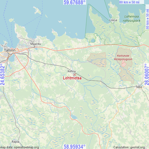
Lehtmetsa GPS coordinates[2]
59° 19' 12" North, 25° 21' 24.984" East
| Map corner | latitude | longitude |
|---|---|---|
| Upper-left | 59.67688°, | 24.65382° |
| Center: | 59.32°, | 25.35694° |
| Lower-right: | 58.95934°, | 26.06007° |
| Map W x H: | 79.8×79.8 km | = 49.6×49.6mi |
| max Lat: | 59.57639° ⇑26.3% North |
| Lehtmetsa: | 59.32° |
| min Lat: | ⇓73.7% South 57.72778° |
| min Long | Lehtmetsa | max Long |
| 22.24646° | 25.35694° | 28.19028° |
| W 46.3%⇐ | ⇒53.7% E |
Elevation
Elevation of Lehtmetsa is 59 m = 194 ft, and this is 5.8 m = 19 ft above average elevation for this country.
| Max E: |
141 m = 463 ft | 42.6% |
| Lehtmetsa | 59 m 194 ft | |
| Avg. | 53.2 m = 175 ft | |
Min E: |
6 m = 20 ft | 57.4% |
See also: Estonia elevation on elevation.city.
Geographical zone
Lehtmetsa is located in North temperate zone (between Tropic of Cancer and the Arctic Circle). Distance of this North polar circle is 805.4 km =500.5 mi to North.| Distance of | km | miles | from Lehtmetsa |
|---|---|---|---|
| North Pole | 3411.3 | 2119.7 | to North |
| Arctic Circle | 805.4 | 500.5 | to North |
| Tropic Cancer | 3989.8 | 2479.1 | to South |
| Equator | 6595.8 | 4098.4 | to South |


Nearby cities:
15 places around Lehtmetsa: (largest is in red/bold)
• Aegviidu
15.1 km =9.4 mi,  104°
104°
• Ardu
24.4 km =15.2 mi,  178°
178°
• Aruküla
16.7 km =10.4 mi,  288°
288°
• Jüri
26.5 km =16.5 mi,  278°
278°
• Kehra
2.7 km =1.7 mi,  311°
311°
• Kiiu
14.3 km =8.9 mi,  5°
5°
• Kose
18.9 km =11.7 mi,  213°
213°
• Kose-Uuemõisa
19.6 km =12.2 mi,  226°
226°
• Kostivere
18.9 km =11.7 mi, 309°
• Kuusalu
14.6 km =9.1 mi,  19°
19°
• Lagedi
25.5 km =15.8 mi, 291°
• Loo
26.2 km =16.3 mi,  298°
298°
• Raasiku
11.1 km =6.9 mi, 297°
• Vaida
21.8 km =13.5 mi,  259°
259°
• Valkla
17.1 km =10.6 mi,  353°
353°
Sources, notices
• [Note1] Compared only with cities in Estonia existing in our database
• [Src1] Map data: © OpenStreetMap contributors (CC-BY-SA)
• [Src2] Other city data from geonames.org with taken over terms of usage.
• [Src3] Geographical zone / Annual Mean Temperature by Robert A. Rohde @ Wikipedia
