Villamalur geodata
Villamalur (Valencia) is a seat of a third-order administrative division; located in Spain in Europe/Madrid (GMT+2) time zone. With population of 105 people, there are 5867 cities with bigger population in this country. Compared to other cities in Spain, 70.7% of cities are located further ↑North; 83.1% of cities are located further ←West and 57.8% of cities have higher elevation than Villamalur. Note1


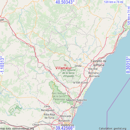
Villamalur GPS coordinates[2]
39° 58' 0.012" North, 0° 24' 0" West
| Map corner | latitude | longitude |
|---|---|---|
| Upper-left | 40.50343°, | -1.10313° |
| Center: | 39.96667°, | -0.4° |
| Lower-right: | 39.42566°, | 0.30313° |
| Map W x H: | 119.8×119.8 km | = 74.4×74.4mi |
| max Lat: | 43.74134° ⇑70.7% North |
| Villamalur: | 39.96667° |
| min Lat: | ⇓29.3% South 27.64134° |
| min Long | Villamalur | max Long |
| -18.00367° | -0.4° | 4.2899° |
| W 83.1%⇐ | ⇒16.9% E |
Elevation
Elevation of Villamalur is 554 m = 1818 ft, and this is 44 m = 144 ft below average elevation for this country.
| Max E: |
1682 m = 5518 ft | 57.8% |
| Avg. | 598 m = 1962 ft | |
| Villamalur | 554 m = 1818 ft | |
Min E: |
0 m = 0 ft | 42.2% |
See also: Spain elevation on elevation.city.
Geographical zone
Villamalur is located in North temperate zone (between Tropic of Cancer and the Arctic Circle). Distance of this Northern Tropic circle is 1838 km =1142.1 mi to South.| Distance of | km | miles | from Villamalur |
|---|---|---|---|
| North Pole | 5563.2 | 3456.8 | to North |
| Arctic Circle | 2957.3 | 1837.6 | to North |
| Tropic Cancer | 1838 | 1142.1 | to South |
| Equator | 4443.9 | 2761.3 | to South |


Nearby cities:
15 places around Villamalur: (largest is in red/bold)
• Alcudia de Veo
7 km =4.3 mi,  142°
142°
• Algimia de Almonacid
6.2 km =3.9 mi,  207°
207°
• Ayódar
4.7 km =2.9 mi,  37°
37°
• Espadilla
8.5 km =5.3 mi,  29°
29°
• Fanzara
9 km =5.6 mi,  51°
51°
• Fuentes de Ayódar
7.5 km =4.7 mi,  349°
349°
• Gaibiel
8 km =5 mi,  242°
242°
• Higueras
8.7 km =5.4 mi,  282°
282°
• Matet
6.8 km =4.2 mi, 236°
• Pavías
7.1 km =4.4 mi,  270°
270°
• Tales
8.2 km =5.1 mi,  104°
104°
• Toga
9.7 km =6 mi,  17°
17°
• Torralba del Pinar
3.4 km =2.1 mi,  303°
303°
• Torrechiva
9.3 km =5.8 mi,  0°
0°
• Vall de Almonacid
8.6 km =5.3 mi, 209°
Sources, notices
• [Note1] Compared only with cities in Spain existing in our database
• [Src1] Map data: © OpenStreetMap contributors (CC-BY-SA)
• [Src2] Other city data from geonames.org with taken over terms of usage.
• [Src3] Geographical zone / Annual Mean Temperature by Robert A. Rohde @ Wikipedia
