Higueras geodata
Higueras (Valencia) is a seat of a third-order administrative division; located in Spain in Europe/Madrid (GMT+2) time zone. With population of 91 people, there are 6042 cities with bigger population in this country. Compared to other cities in Spain, 70.5% of cities are located further ↑North; 81.7% of cities are located further ←West and 52.8% of cities have lower elevation than Higueras. Note1


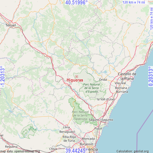
Higueras GPS coordinates[2]
39° 58' 59.988" North, 0° 30' 0" West
| Map corner | latitude | longitude |
|---|---|---|
| Upper-left | 40.51996°, | -1.20313° |
| Center: | 39.98333°, | -0.5° |
| Lower-right: | 39.44245°, | 0.20313° |
| Map W x H: | 119.8×119.8 km | = 74.4×74.4mi |
| max Lat: | 43.74134° ⇑70.5% North |
| Higueras: | 39.98333° |
| min Lat: | ⇓29.5% South 27.64134° |
| min Long | Higueras | max Long |
| -18.00367° | -0.5° | 4.2899° |
| W 81.7%⇐ | ⇒18.3% E |
Elevation
Elevation of Higueras is 688 m = 2257 ft, and this is 90 m = 295 ft above average elevation for this country.
| Max E: |
1682 m = 5518 ft | 47.2% |
| Higueras | 688 m 2257 ft | |
| Avg. | 598 m = 1962 ft | |
Min E: |
0 m = 0 ft | 52.8% |
See also: Spain elevation on elevation.city.
Geographical zone
Higueras is located in North temperate zone (between Tropic of Cancer and the Arctic Circle). Distance of this Northern Tropic circle is 1839.8 km =1143.2 mi to South.| Distance of | km | miles | from Higueras |
|---|---|---|---|
| North Pole | 5561.3 | 3455.6 | to North |
| Arctic Circle | 2955.4 | 1836.4 | to North |
| Tropic Cancer | 1839.8 | 1143.2 | to South |
| Equator | 4445.7 | 2762.4 | to South |


Nearby cities:
15 places around Higueras: (largest is in red/bold)
• Algimia de Almonacid
9.3 km =5.8 mi,  142°
142°
• Arañuel
9.4 km =5.8 mi,  8°
8°
• Caudiel
6.8 km =4.2 mi,  236°
236°
• Cirat
8.5 km =5.3 mi,  29°
29°
• Fuentes de Ayódar
9 km =5.6 mi,  51°
51°
• Gaibiel
5.7 km =3.5 mi,  165°
165°
• Jérica
9.3 km =5.8 mi,  217°
217°
• Matet
6.2 km =3.9 mi,  152°
152°
• Montanejos
9.4 km =5.8 mi,  351°
351°
• Montán
7 km =4.3 mi,  322°
322°
• Navajas
11.1 km =6.9 mi,  180°
180°
• Pavías
2.3 km =1.4 mi, 142°
• Torralba del Pinar
5.7 km =3.5 mi,  90°
90°
• Vall de Almonacid
10.2 km =6.3 mi,  155°
155°
• Villamalur
8.7 km =5.4 mi,  102°
102°
Sources, notices
• [Note1] Compared only with cities in Spain existing in our database
• [Src1] Map data: © OpenStreetMap contributors (CC-BY-SA)
• [Src2] Other city data from geonames.org with taken over terms of usage.
• [Src3] Geographical zone / Annual Mean Temperature by Robert A. Rohde @ Wikipedia
