Ayódar geodata
Ayódar (Valencia) is a seat of a third-order administrative division; located in Spain in Europe/Madrid (GMT+2) time zone. With population of 227 people, there are 4876 cities with bigger population in this country. Compared to other cities in Spain, 70.3% of cities are located further ↑North; 83.5% of cities are located further ←West and 66.3% of cities have higher elevation than Ayódar. Note1


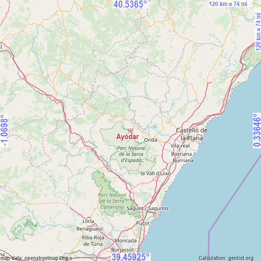
Ayódar GPS coordinates[2]
40° 0' 0" North, 0° 22' 0.012" West
| Map corner | latitude | longitude |
|---|---|---|
| Upper-left | 40.5365°, | -1.0698° |
| Center: | 40°, | -0.36667° |
| Lower-right: | 39.45925°, | 0.33646° |
| Map W x H: | 119.8×119.8 km | = 74.4×74.4mi |
| max Lat: | 43.74134° ⇑70.3% North |
| Ayódar: | 40° |
| min Lat: | ⇓29.7% South 27.64134° |
| min Long | Ayódar | max Long |
| -18.00367° | -0.36667° | 4.2899° |
| W 83.5%⇐ | ⇒16.5% E |
Elevation
Elevation of Ayódar is 443 m = 1453 ft, and this is 155 m = 509 ft below average elevation for this country.
| Max E: |
1682 m = 5518 ft | 66.3% |
| Avg. | 598 m = 1962 ft | |
| Ayódar | 443 m = 1453 ft | |
Min E: |
0 m = 0 ft | 33.7% |
See also: Spain elevation on elevation.city.
Geographical zone
Ayódar is located in North temperate zone (between Tropic of Cancer and the Arctic Circle). Distance of this Northern Tropic circle is 1841.7 km =1144.4 mi to South.| Distance of | km | miles | from Ayódar |
|---|---|---|---|
| North Pole | 5559.5 | 3454.5 | to North |
| Arctic Circle | 2953.6 | 1835.3 | to North |
| Tropic Cancer | 1841.7 | 1144.4 | to South |
| Equator | 4447.6 | 2763.6 | to South |


Nearby cities:
15 places around Ayódar: (largest is in red/bold)
• Alcudia de Veo
9.4 km =5.8 mi,  171°
171°
• Argelita
5.7 km =3.5 mi,  14°
14°
• Cirat
9 km =5.6 mi,  308°
308°
• Espadilla
4 km =2.5 mi,  20°
20°
• Fanzara
4.6 km =2.9 mi,  66°
66°
• Fuentes de Ayódar
5.6 km =3.5 mi, 311°
• Ludiente
9.3 km =5.8 mi,  0°
0°
• Onda
9.9 km =6.2 mi,  113°
113°
• Pavías
10.6 km =6.6 mi,  249°
249°
• Ribesalbes
8.7 km =5.4 mi,  77°
77°
• Tales
7.7 km =4.8 mi,  138°
138°
• Toga
5.6 km =3.5 mi, 0°
• Torralba del Pinar
6 km =3.7 mi, 251°
• Torrechiva
6.2 km =3.9 mi,  332°
332°
• Villamalur
4.7 km =2.9 mi,  217°
217°
Sources, notices
• [Note1] Compared only with cities in Spain existing in our database
• [Src1] Map data: © OpenStreetMap contributors (CC-BY-SA)
• [Src2] Other city data from geonames.org with taken over terms of usage.
• [Src3] Geographical zone / Annual Mean Temperature by Robert A. Rohde @ Wikipedia
