Valdehúncar geodata
Valdehúncar (Extremadura) is a seat of a third-order administrative division; located in Spain in Europe/Madrid (GMT+2) time zone. With population of 207 people, there are 4996 cities with bigger population in this country. Compared to other cities in Spain, 72.4% of cities are located further ↑North; 78.9% of cities are located further →East and 70.6% of cities have higher elevation than Valdehúncar. Note1


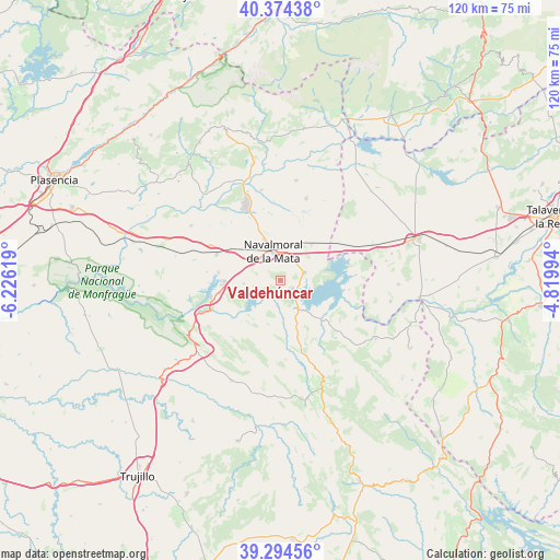
Valdehúncar GPS coordinates[2]
39° 50' 11.724" North, 5° 31' 23.052" West
| Map corner | latitude | longitude |
|---|---|---|
| Upper-left | 40.37438°, | -6.22619° |
| Center: | 39.83659°, | -5.52307° |
| Lower-right: | 39.29456°, | -4.81994° |
| Map W x H: | 120.1×120.1 km | = 74.6×74.6mi |
| max Lat: | 43.74134° ⇑72.4% North |
| Valdehúncar: | 39.83659° |
| min Lat: | ⇓27.6% South 27.64134° |
| min Long | Valdehúncar | max Long |
| -18.00367° | -5.52307° | 4.2899° |
| W 21.1%⇐ | ⇒78.9% E |
Elevation
Elevation of Valdehúncar is 372 m = 1220 ft, and this is 226 m = 741 ft below average elevation for this country.
| Max E: |
1682 m = 5518 ft | 70.6% |
| Avg. | 598 m = 1962 ft | |
| Valdehúncar | 372 m = 1220 ft | |
Min E: |
0 m = 0 ft | 29.4% |
See also: Spain elevation on elevation.city.
Geographical zone
Valdehúncar is located in North temperate zone (between Tropic of Cancer and the Arctic Circle). Distance of this Northern Tropic circle is 1823.5 km =1133.1 mi to South.| Distance of | km | miles | from Valdehúncar |
|---|---|---|---|
| North Pole | 5577.6 | 3465.8 | to North |
| Arctic Circle | 2971.8 | 1846.6 | to North |
| Tropic Cancer | 1823.5 | 1133.1 | to South |
| Equator | 4429.4 | 2752.3 | to South |


Nearby cities:
15 places around Valdehúncar: (largest is in red/bold)
• Almaraz
13.4 km =8.3 mi,  259°
259°
• Belvis de Monroy
7.6 km =4.7 mi, 255°
• Berrocalejo
14.9 km =9.3 mi,  97°
97°
• Bohonal de Ibor
6.6 km =4.1 mi,  150°
150°
• Campillo de Deleitosa
15.5 km =9.6 mi,  196°
196°
• Casatejada
14.6 km =9.1 mi,  292°
292°
• Fresnedoso de Ibor
17 km =10.6 mi,  175°
175°
• Higuera
17.4 km =10.8 mi,  224°
224°
• Mesas de Ibor
9.2 km =5.7 mi,  192°
192°
• Millanes
5.1 km =3.2 mi, 285°
• Navalmoral de la Mata
6.3 km =3.9 mi,  346°
346°
• Peraleda de San Román
15.7 km =9.8 mi,  132°
132°
• Peraleda de la Mata
5.6 km =3.5 mi,  71°
71°
• Saucedilla
13.3 km =8.3 mi,  277°
277°
• Valdecañas de Tajo
11.9 km =7.4 mi, 223°
Sources, notices
• [Note1] Compared only with cities in Spain existing in our database
• [Src1] Map data: © OpenStreetMap contributors (CC-BY-SA)
• [Src2] Other city data from geonames.org with taken over terms of usage.
• [Src3] Geographical zone / Annual Mean Temperature by Robert A. Rohde @ Wikipedia
