Berrocalejo geodata
Berrocalejo (Extremadura) is a seat of a third-order administrative division; located in Spain in Europe/Madrid (GMT+2) time zone. With population of 118 people, there are 5722 cities with bigger population in this country. Compared to other cities in Spain, 72.6% of cities are located further ↑North; 76.9% of cities are located further →East and 70.3% of cities have higher elevation than Berrocalejo. Note1


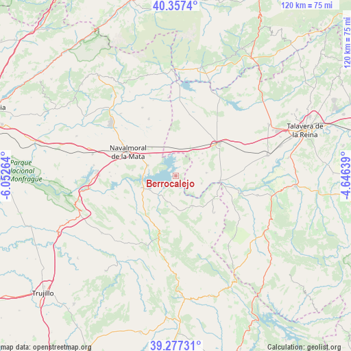
Berrocalejo GPS coordinates[2]
39° 49' 10.128" North, 5° 20' 58.236" West
| Map corner | latitude | longitude |
|---|---|---|
| Upper-left | 40.3574°, | -6.05264° |
| Center: | 39.81948°, | -5.34951° |
| Lower-right: | 39.27731°, | -4.64639° |
| Map W x H: | 120.1×120.1 km | = 74.6×74.6mi |
| max Lat: | 43.74134° ⇑72.6% North |
| Berrocalejo: | 39.81948° |
| min Lat: | ⇓27.4% South 27.64134° |
| min Long | Berrocalejo | max Long |
| -18.00367° | -5.34951° | 4.2899° |
| W 23.1%⇐ | ⇒76.9% E |
Elevation
Elevation of Berrocalejo is 376 m = 1234 ft, and this is 222 m = 728 ft below average elevation for this country.
| Max E: |
1682 m = 5518 ft | 70.3% |
| Avg. | 598 m = 1962 ft | |
| Berrocalejo | 376 m = 1234 ft | |
Min E: |
0 m = 0 ft | 29.7% |
See also: Spain elevation on elevation.city.
Geographical zone
Berrocalejo is located in North temperate zone (between Tropic of Cancer and the Arctic Circle). Distance of this Northern Tropic circle is 1821.6 km =1131.9 mi to South.| Distance of | km | miles | from Berrocalejo |
|---|---|---|---|
| North Pole | 5579.6 | 3467 | to North |
| Arctic Circle | 2973.7 | 1847.8 | to North |
| Tropic Cancer | 1821.6 | 1131.9 | to South |
| Equator | 4427.5 | 2751.1 | to South |


Nearby cities:
15 places around Berrocalejo: (largest is in red/bold)
• Alcolea de Tajo
17.3 km =10.7 mi,  93°
93°
• Bohonal de Ibor
12.2 km =7.6 mi,  251°
251°
• Caleruela
10 km =6.2 mi,  52°
52°
• El Puente del Arzobispo
15.3 km =9.5 mi,  97°
97°
• Garvín
11.1 km =6.9 mi,  178°
178°
• Herreruela de Oropesa
12 km =7.5 mi, 49°
• La Calzada de Oropesa
10.7 km =6.6 mi,  34°
34°
• Lagartera
15.9 km =9.9 mi, 52°
• Peraleda de San Román
9.3 km =5.8 mi,  200°
200°
• Peraleda de la Mata
10.2 km =6.3 mi,  291°
291°
• Torrico
10.6 km =6.6 mi,  84°
84°
• Valdehúncar
14.9 km =9.3 mi,  277°
277°
• Valdelacasa de Tajo
11.9 km =7.4 mi,  151°
151°
• Valdeverdeja
9.3 km =5.8 mi,  106°
106°
• Villar del Pedroso
18.2 km =11.3 mi,  133°
133°
Sources, notices
• [Note1] Compared only with cities in Spain existing in our database
• [Src1] Map data: © OpenStreetMap contributors (CC-BY-SA)
• [Src2] Other city data from geonames.org with taken over terms of usage.
• [Src3] Geographical zone / Annual Mean Temperature by Robert A. Rohde @ Wikipedia
