Tuéjar geodata
Tuéjar (Valencia) is a seat of a third-order administrative division; located in Spain in Europe/Madrid (GMT+2) time zone. With population of 1,212 people, there are 2715 cities with bigger population in this country. Compared to other cities in Spain, 73.3% of cities are located further ↑North; 76.9% of cities are located further ←West and 52.1% of cities have lower elevation than Tuéjar. Note1


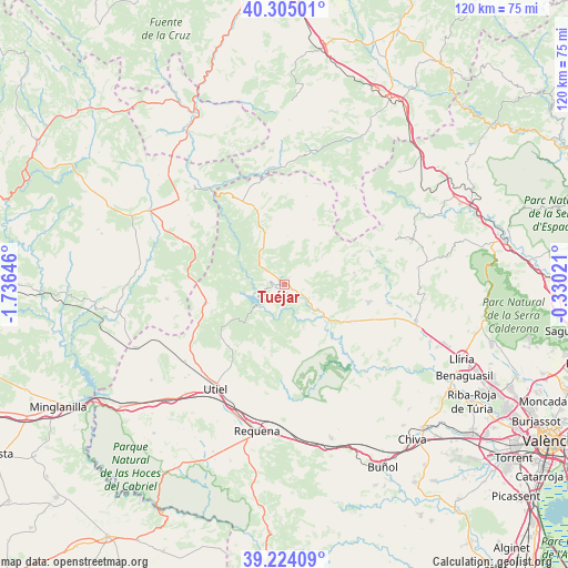
Tuéjar GPS coordinates[2]
39° 46' 0.012" North, 1° 1' 59.988" West
| Map corner | latitude | longitude |
|---|---|---|
| Upper-left | 40.30501°, | -1.73646° |
| Center: | 39.76667°, | -1.03333° |
| Lower-right: | 39.22409°, | -0.33021° |
| Map W x H: | 120.2×120.2 km | = 74.7×74.7mi |
| max Lat: | 43.74134° ⇑73.3% North |
| Tuéjar: | 39.76667° |
| min Lat: | ⇓26.7% South 27.64134° |
| min Long | Tuéjar | max Long |
| -18.00367° | -1.03333° | 4.2899° |
| W 76.9%⇐ | ⇒23.1% E |
Elevation
Elevation of Tuéjar is 681 m = 2234 ft, and this is 83 m = 272 ft above average elevation for this country.
| Max E: |
1682 m = 5518 ft | 47.9% |
| Tuéjar | 681 m 2234 ft | |
| Avg. | 598 m = 1962 ft | |
Min E: |
0 m = 0 ft | 52.1% |
See also: Spain elevation on elevation.city.
Geographical zone
Tuéjar is located in North temperate zone (between Tropic of Cancer and the Arctic Circle). Distance of this Northern Tropic circle is 1815.7 km =1128.2 mi to South.| Distance of | km | miles | from Tuéjar |
|---|---|---|---|
| North Pole | 5585.4 | 3470.6 | to North |
| Arctic Circle | 2979.5 | 1851.4 | to North |
| Tropic Cancer | 1815.7 | 1128.2 | to South |
| Equator | 4421.6 | 2747.5 | to South |


Nearby cities:
15 places around Tuéjar: (largest is in red/bold)
• Alpuente
11.2 km =7 mi,  7°
7°
• Andilla
21.3 km =13.2 mi,  69°
69°
• Benagéber
8 km =5 mi,  225°
225°
• Calles
7.4 km =4.6 mi,  133°
133°
• Chelva
3.7 km =2.3 mi,  121°
121°
• Chera
19.4 km =12.1 mi,  162°
162°
• Chulilla
18.2 km =11.3 mi,  135°
135°
• Higueruelas
15.8 km =9.8 mi,  83°
83°
• La Yesa
14.8 km =9.2 mi,  28°
28°
• Loriguilla
13.6 km =8.5 mi, 132°
• Losa del Obispo
16.1 km =10 mi, 117°
• Sinarcas
17.5 km =10.9 mi,  257°
257°
• Sot de Chera
18.7 km =11.6 mi, 142°
• Titaguas
11.9 km =7.4 mi,  338°
338°
• Villar del Arzobispo
18.9 km =11.7 mi,  101°
101°
Sources, notices
• [Note1] Compared only with cities in Spain existing in our database
• [Src1] Map data: © OpenStreetMap contributors (CC-BY-SA)
• [Src2] Other city data from geonames.org with taken over terms of usage.
• [Src3] Geographical zone / Annual Mean Temperature by Robert A. Rohde @ Wikipedia
